
Discover 400
Sussex Walks.


Fancy a new adventure? Explore the best Sussex walks.

Our walking app provides easy to follow routes, showing your position on the map as you walk. It uses your phone GPS to guide you and gives you the confidence to explore and enjoy new walks in Sussex. So, if you are looking for your next Sussex walking adventure, download the app, choose a walk and just follow the pointer.
It’s like sat-nav… but for footpaths.
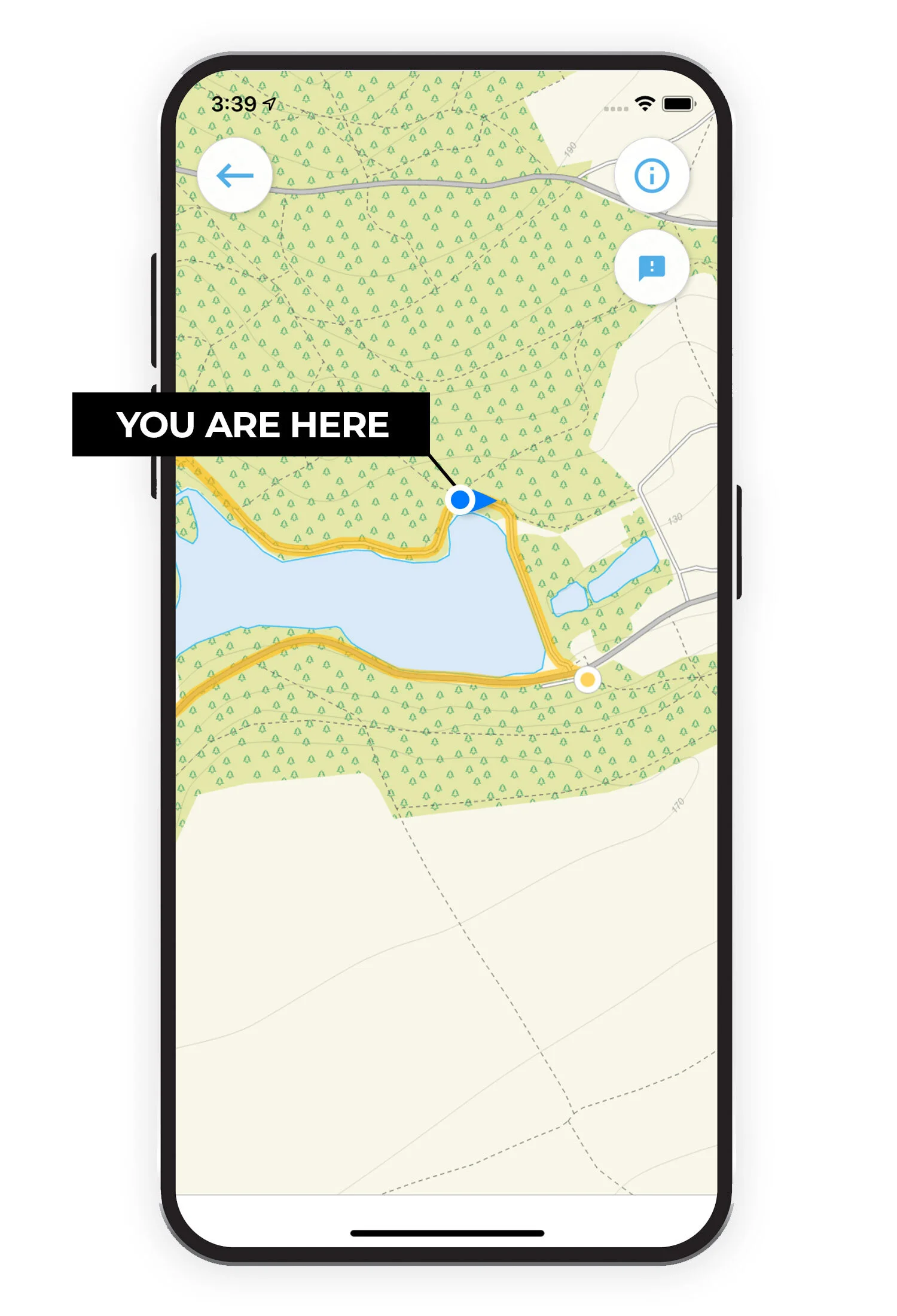
See your position on the route map as you walk.
Our mobile walking guide app includes 400 walks in and around Sussex. Download Sussex Walks on the iTunes app store or Sussex Walks on the Google Play app store.

Join our community.
facebook.com/walks.sussex
Like us on Facebook and join the 1,000’s of people who recommend, discover, feedback and enjoy new walks in Sussex.
We love discovering new Sussex walks and our growing community help us find the best walks so that we can research and share them in the app. Our users can rate each walk based on a number of factors such as how dog or buggy friendly it is, pub on route etc, so that you can find your perfect walks.
If you want to join our community, just head over to facebook.com/walks.sussex and get involved!
Check out a few of our Sussex walks…


Here is a list of the Sussex Walks we have on the app so far…
Abbots Wood
0.75 miles
This is the shortest of the woodland walks in Abbots Wood. It's known as the Oak Walk Trail and it is a circular walk that enjoys and Oak woodland and is especially nice in the spring when the Bluebells are in bloom.
Abbots Wood
1.5 miles
This second route is slightly longer than the first route and it takes you deeper into the woods, visiting a lake that was dug by monks in the 13th century as it takes you on an adventure through this beautiful area of woodland.
Amberley
2.75 miles
This is a nice and short family-friendly stroll alongside a lovely stretch of the River Arun. The walk also takes you through the village of Houghton, where there's a pub to enjoy if you don't mind the short detour.
Amberley
3.25 miles
This second route is also one of our shorter walks from Amberley station. This walk heads north along the lovely River Arun and then loops back through countryside and quiet country lanes, visiting the village of Amberley on the way. The route passes a pub in Amberley and there is another pub next to Amberley Station for refreshments.
Amberley
4.75 miles
This third option is a longer walk that is effectively an extension of the first route. This extension enjoys a big loop of extra walking alongside the River until you reach the village of South Stoke. It then works its way back to the start through pretty countryside. There is a pub in the village of Houghton, just a short detour from the route.
Amberley
7 miles
This fourth option is the one for you if you really want a work out, whilst enjoying a wonderfully varied walk in the South Downs. One half of the walk is effectively the second route, enjoying the River Arun and the village of Amberley with it's pub. However, this extended walk then takes you on a glorious loop up into the Downs themselves along the South Downs Way. This extra section has a fair bit of climbing, but you will be rewarded for your efforts with some lovely views.
Amberley
11.5 miles
This final route is for those of you that want a truly epic adventure workout in this lovely part of the South Downs national park. It enjoys a very long stretch of walking alongside the River Arun, as well as lots of hilly walking in the South Downs with majestic views. You really will need your energy for this long walk, and there is a nice pub in the village of Amberley if you need refreshments.
Arlington Reservoir
3 miles
This walk is a nice and simple family-friendly short stroll around the pretty Arlington Reservoir with a short stretch of walking through some farmland to get to the reservoir itself.
Arlington Reservoir
3.25 miles
This second route is basically a longer extension of the Arlington Reservoir walk. It still enjoys the waterside walking of course, but then takes you on a longer loop out into some peaceful countryside and farmland.
Arundel
We have 3 Arundel walks on the app.
Ashdown Forest walks of 1 mile to 3.25 miles.
Barcombe Cross
2.5 miles
The second route is the glory walk from Barcombe Cross, but this first route is a nice and simple alternative if you want a short family friendly countryside walk. The walk is mainly made up of footpaths through open countryside and farmland but there is also a short section of walking through Knowlands Wood. There is then a nice village pub to enjoy in the village after your walk.
Barcombe Cross
5.5 miles
This is a wonderful and varied walk in the pretty countryside that you'll find around the village of Burcombe Cross. The walk has a bit of everything including lots of open countryside, a long walk alongside the River Ouse, a short walk through some woodland, a visit to the other villages of Barcombe and Barcombe Mills and two lovely pubs. One of the pubs is in the Barcombe Cross village high street itself, and the other is a riverside pub about half way around the route.
Battle
4.5 miles
This is a well-trodden and lovely circular walk around the town of Battle. It starts at the train station car park (so you can train to the start as well if you wish) and takes you on an adventure into the majestic Great Wood. There is some hills to climb on this route and some roadside walking.
Battle
6.25 miles
This second route option is basically an extension to the first walk. As well as enjoying Battle Hill and the Great Wood, it also heads off on an adventure to Caldbec Hill that you'll find to the north of the town. There are some pubs in Battle for refreshments and there is some quiet roadside walking on the route.
Beachy Head
2.25 miles
This is a lovely short family-friendly coastal walk around the Beachy Head chalk headland. There is some climbing involved on this walk, but you will be rewarded with some lovely coastal views. As with all coastal walks, please be extremely careful when walking close to any cliff edges.
Beachy Head
3.75 miles
This second walk is an extension of the first route for those of you that have the energy for a more strenuous adventure. This route enjoys a bit more of the open clifftop walking around Beachy Head and also has a small detour to a pub if you want to make this a Pub Walk. Finally, there is also another detour that takes you down to the sea at Cow Gap. As with the first route, please be very careful when close to any cliff edges.
Take a look at our Bedelands walks here
Bedgebury Pinetum
1.25 miles
Just over the border into Kent, you'll find the wonderful Bedgebury Pinetum which is a recreational and conservational arboretum with lots of wonderful trees and a lake to enjoy. This first walk is a splendid stroll around the heart of the Pinetum and the route is on solid wheel-friendly paths throughout. Please note: There is a fee to use the car park, so please check 'Bedgebury Pinetum' website online to check opening times and prices.
Bedgebury Pinetum
1.75 miles
This second route is basically a slightly longer route that goes a bit more 'off-piste' so to speak and explores the hidden secrets of the Pinetum. The route leaves the solid paths in places so it's not as suitable for wheels. Please note: There is a fee to use the car park, so please check 'Bedgebury Pinetum' website online to check opening times and prices.
Beeding Hill
3.25 miles
This is a lovely short family-friendly walk around the wonderful Beeding Hill in the South Downs national park. This route has a fair bit of climbing, so you'll need plenty of energy, but it has less climbing than the second route whilst still enjoying the wonderful views. The price you pay for the reduced hill climbing is a third of the route is walking along a quiet lane, but it's not too busy and the panoramic views are breathtaking.
Beeding Hill
3.75 miles
The second route still enjoys the wonderful views of Beeding Hill in the South Downs national park, but in order to avoid the road walking, it takes you on an adventure some way down the hill itself meaning you have more climbing to do on this route.
Benbow Pond
1 mile
This is a short and gentle family-friendly walk in some pretty countryside inside Cowdray Park. You will park by the pretty lake where you can enjoy feeding the ducks or have a nice picnic. Then, the short walk takes you north through some open countryside before taking you through a young avenue of trees that was planted in 2012 and then through the lovely John Cowdray arboretum.
Benbow Pond
6.75 miles
This second route option is a longer and much more strenuous adventure that explores all the lovely undulating countryside that you'll find in this area of West Sussex. You'll still enjoy the pond and arboretum from the first walk, but with this route you'll also get a lot more hilly walking through pretty countryside and a visit to the village of Easebourne with it's charismatic village pub for well earned refreshments. Please note: The route also takes you on a public footpath that passes through a golf course, so please respect the golfers on this section and keep an eye out for flying balls!
Bersted Brooks
1 mile
This is a nice and short family-friendly stroll around the Bersted Brooks Nature Reserve. The reserve has a varied selection of habitats including mature trees, hedgerows, ditches, scrub & wetland and is home to many forms of wildlife.
Bersted Brooks
1.75 miles
This second route is basically just a short extension to the first route if you have a little bit more tome to explore this pleasant Nature Reserve.
Bewl Water
13.5 miles
This is an epic adventure walk that takes you all the way around the lovely Bewl Water lake. You need to allow a whole day to enjoy this one and there is a fee to enter/park so check their website for opening times and current costs.
Bignor Hill
1.5 miles to 9.25 miles
Billingshurst
1.25 miles
This is a nice and simple countryside circular stroll from the Jubilee Fields park in Billingshurst. There is some walking along a quiet country lane and there could also be some livestock on this route.
Billingshurst
9.75 miles
In contrast to the first short stroll, the second route option is an epic and varied adventure from the Jubilee Fields park in Billingshurst. You can expect lots of peaceful countryside walking on the route but the highlight of this route is the long winding walk alongside the pretty River Arun. That said, some might argue that the actual highlight is the lovely pub in the Wisborough Green village green that will no doubt gladly provide you with some well deserved refreshments half way around the walk. There are some sections of road walking at times on the route, so please be careful on these sections. Additionally, as it's a long walk, please be careful with your battery use and only use the app when you need to for navigation.
Birchden Wood
1.25 miles
This is a lovely family-friendly stroll around the pretty Birchden Woods. This first route option has a bit of going back on yourself, but it is all hard surface/fine stones so its a good walk for wheelchairs and buggies.
Birchden Wood
1.5 miles
This second route is just a slightly longer version of the walk in the lovely Birchden Woods. The paths are not all hard surface like the first route, but the loop is complete and doesn't go back on itself.
Birling Gap
1.5 miles and 3 miles
Black Down
Walks of 1.5 miles and 3 miles
Blunt's Wood
1 mile
This is a lovely short family-friendly walk around Blunt's Wood and the Paiges Meadow Nature Reserve. You can expect sections of pretty woodland walking and a long walk around the meadow with it's abundant wildlife on offer.
Bramber
2 miles
This first route is a lovely short family friendly pub walk form the pretty village of Bramber. Heading clockwise, the walk first takes you on a short stroll around the remains of the Norman Bramber Castle (there is a small charge for the car park for non members). It then takes you out through countryside for a while before meeting the pretty River Adur for a lovely riverside amble that eventually gets you back to the village where you can walk down the pretty high street and find some pub options for refreshments.
Bramber
3.5 miles
The second route is an extension to the first route that doesn't take you through the Bramber high street for the pub (although you can easily stroll in if you wish). Instead, it extends the loop to make a longer walk that enjoys a lot more walking alongside the lovely River Adur.
Bramber
6.75 miles
The final route is a longer and more strenuous walk that still enjoys the castle remains and lovely riverside walking, but it then also heads off on an adventure along the South Downs Way for a climb up Annington Hill. You'll need more time and energy on this route, but you'll then also be rewarded with some lovely views. There is a short section of roadside walking on the route, so please be careful here.
Brede High Woods
1.25 miles
Brede High Woods is a wonderful woodland area made up of 10 different ancient woods and it's full of fabulous wildlife and diverse habitats. This short family-friendly route is the best route for you if you want a short stroll in one of these ancient woods.
Brede High Woods
2.75 miles
If you have a bit more time, then the second route is a slightly longer loop that explores two of the ancient woods to the west of the car park. You can do both routes 1 and 2 together to form a long figure of 8 walk if you wish.
Brede High Woods
5 miles
This final route is the longest route that gives you a wonderful adventure around a large section of this great woodland and surrounding countryside. You can expect a varied walk with fantastic woodland and wildlife as well as some bonus fantastic views. There is a small section of road walking on this route and some moderate climbing.
Broadwater Warren
2.25 miles
This is a delightful family friendly walk around the wonderful heathland of Broadwater Warren. You can expect to find some lovely viewpoints and lots of nature on this walk. Dogs must be kept on leads at all times.
Broadwater Warren
4.25 miles
This second route is a longer extension of the first walk for those of you that have a bit more time and energy to explore the interesting and beautiful Broadwater Warren. You will explore lots more of the lovely woodland, roam through the wonderful Heathland with it's abundance of nature and also visit the Eridge Rocks nature reserve with it's woodland, veteran trees and ancient sandstone rock formations.
Buchan Country Park
0.75 miles and 2 miles
Burpham
2 miles
This is a lovely short walk from the village of Burpham. You'll visit the village itself, explore some countryside, and have a stroll alongside the river Arun. There's then a pub in the village for some post walk refreshments if you need making this a nice day out for all the family.
Burpham
3.25 miles
This second route is not too long in terms of distance, but you'll need some energy in the tank as it takes you north out of the village and climbs to the summit of Perry Hill. The effort will be worth it though when you get to enjoy the lovely views and then visit the village pub after your walk.
Burpham
7.75 miles
This final route is a much longer route from the village of Burpham and it's one for those of you that really want to stretch your legs and have an epic adventure in the downs before getting back to the pub for your reward. The walk heads north from the village and then enjoys a glorious section of the South Downs Way that takes you over Rachham Hill and Springhead Hill. Go prepared for an energetic walk with wonderful views!
Burwash
2.75 miles
This is a lovely and simple countryside walk in the undulating countryside that you'll find around Burwash Weald. There is some moderate climbing involved on the walk and half way around there is a detour to go and visit the National Trust Batemans House if you wish (visit their website for entry fees).
Buxted Park
2 miles
This is a lovely and short family-friendly stroll around the beautiful Buxted Park Deer Park. The walk has a bit of everything with a lake to stroll around, some open countryside to enjoy and some pretty woodland.
Chanctonbury Ring
Walks of 2.5 miles to 8.75 miles
Chantry Hill
1.75 miles
This is a lovely short family-friendly walking loop around the top of Chantry hill. The car park is already at the top of the hill, so you can enjoy this walk's wonderful views without having to climb too much.
Chantry Hill
2.5 miles
This second route is not much longer than the first route in distance, but it is a lot more energetic as it takes you on a loop down to the bottom of Chantry Hill and then back up Sullington Hill. Make sure you go prepared for a work out on this one.
Chantry Hill
6.5 miles
This third route is basically a nice long open countryside walk around the undulating downs south of Chantry Hill. There is some climbing throughout the walk, but it's not too steep at any point. You could also link this to the first route to make a pleasant figure of 8 route with fabulous views, lots of fresh air, but not too much climbing.
Chantry Hill
8 miles
This final route is the 'extreme' version of this walk and it basically takes you on the same long walk around the undulating downs, but then it also takes you on the steep and energetic ascent and descent of Chantry Hill and Sullington hill itself. Expect an epic adventure with fabulous views on this walk.
Charleston House
1.25 miles
This is a short family-friendly stroll around the countryside surrounding Charleston House. You can visit the house itself for a small fee (check their website charleston.org.uk for details) but the walking is free! This short walk offers open countryside and lovely views over the South Downs.
Charleston House
3.5 miles
This second route option is a longer walk from Charleston house. The loop heads west until it reaches the lovely Firle Park and the village of Firle itself. There is then a small detour into the village to find a lovely pub if you want to make this a pub walk.
Charleston House
5.75 miles
This third route option is a longer walk and this loop heads east from the Charleston House area to explore more lovely countryside. This walk also visits the small villages of Alciston and Berwick, where there is a small detour to a wonderful pub for refreshments.
Charleston House
8.5 miles
This final route option is the longest walk from Charleston House and it is the option for you if you have plenty of time and energy and want an epic adventure in this lovely area of countryside. The walk effectively joins together the second and third routes to create a long walk that visits Firle Park, the villages of Firle and Berwick with their lovely pubs to visit.
Chichester
2 miles and 4.25 miles
Chidham
2.5 miles and 5 miles
Church Norton
1.5 miles and 4 miles.
Cissbury Ring
Walks of 2.5 miles to 9.25 miles
Clayton
2.25 miles
There are so many beautiful walks to choose from around the village of Clayton, which is set in the heart of the South Downs National Park. This is the shortest and least strenuous route that takes you on a stroll around Wellcombe Bottom. There is still some climbing on this route, so you will need your energy, but it doesn't take you right to the top of Wolstonbury Hill.
Clayton
3.75 miles
This second route is much tougher than the first route, with some very steep climbing, but you are rewarded when you reach the summit of Wolstonbury Hill with some fantastic views across the South Downs National Park. You'll also visit Wellcombe Bottom and the Ashen Plantation woodland and there's a lovely pub on the route in Clayton to replenish your energy.
Clayton
4.5 miles
This third route heads out east in a different direction to the first two routes, and takes you on an adventure around the open downs. There's a fair bit of climbing on this route again, although not as steep as the Wolstonbury Hill route, and you will be rewarded again with sweeping views. You'll also visit the Clayton Windmills on this route.
Clayton
6.5 miles
This route is an extended version of the third walk that heads further out east from the village of Clayton. This longer energetic walk offers more of the hilly and open countryside walking in the gorgeous South Downs, but you'll also climb to the top of Ditchling Beacon for some especially wonderful views.
Clayton
11 miles
This final route is a truly epic and very challenging long walk in this beautiful area of the South Downs National Park. If you head clockwise, the massive loop explores the expansive opens downs to the east of Clayton before travelling down towards Brighton. It then loops back up through more gorgeous countryside, visiting the village of Pyecombe and then climbing to the summit of Wolstonbury Hill for some wonderful Views. After all of that wonderful walking in the Downs, you'll find a welcome lovely pub with big beer garden as you come back into the village of Clayton.
Cocking Hill
3 miles
This is a relatively short, but strenuous around the summit of Cocking Down and the South Downs Way. You'll need a lot of energy on this walk as it climbs to the summit of the hill, but you will be rewarded with some fabulous views.
Cocking Hill
3.5 miles
This alternative short route heads in the other direction to the first walk. It is still a strenuous walk in this hilly area as it climbs to the top of Heyshott Down for some more great views. However, as an added bonus, this route also visits the village of Cocking where you will find a community pub for energy replenishing refreshments.
Cocking Hill
6.25 miles
This third route is one of our longer walks from this car park. It is again a workout with the moderate climb up to the top of Cocking Down with it's lovely views. However, to then extend the walk, the route takes you on an adventure loop deep into the West Dean Woods.
Copsale
2.25 miles
This is a nice and simple walk in the countryside around the village of Copsale. It's a relatively flat walk, and the main thing to enjoy is the fresh air and open farmland as you stroll around this loop and along the old railway line. There is a short section of walking along a road at the start, so please be careful here.
Copsale
5.25 miles
This second route is effectively an extension of the first route. It still enjoys the simple open countryside paths from the first route, but this extension also enjoys a short section of woodland walking and a visit to the village of Nuthurst where you'll find a pub for some refreshments. As with the first route, there is a short section of walking along a road at the start, so please be careful here.
Crowhurst
2.5 miles
This is a delightful short walk from the pretty village of Crowhurst. The walk heads west from the village and explores the RSPB's Fore Wood Nature Reserve.
Crowhurst
3.5 miles
This second route is basically an extension of the first walk if you want to stretch your legs a bit more. It still enjoys the wonderful nature reserve woodlands, but then extends out further into some open countryside walking with lovely views and fresh air to enjoy.
Crowhurst
4.75 miles
This third route heads in a completely different direction to the other two options and instead it heads south to explore the western end of the Combe Valley Countryside Park. The walk is incredibly varied with sections of woodland, waterside walking, open countryside and a short detour to a lovely pub. You can combine this third route with any of the first two route to create an epic pub walk adventure if you wish and please be aware that there are some sections of road walking on this route, so please be careful.
Darwell Wood
1.25 miles
This is a lovely short woodland stroll around the delightful Darwell Wood. It can be especially wonderful in the spring when you can find carpets of bluebells and wild garlic.
Devil's Dyke
1 mile to 6.5 miles
We have six route from Devil’s Dyke and if you are prepared for some energetic and strenuous walks, you will be rewarded with amazing views across the beautiful South Downs National Park and Sussex countryside. You can read about our Devil’s Dyke walks and view a route map here.
Ditchling Beacon
0.25 miles
We have plenty of epic and strenuous adventures from this car park, but this first route is a just quick stroll to the glory spot: the Ditchling Beacon. It's the choice for you if you don't want any tough climbing and want to spend less time actually walking and more time enjoying the lovely views.
Ditchling Beacon
3 miles
This second route option is still quite a short walk, but it packs a lot of punch in terms of your energy usage, as it descends and then ascends the very steep hill around Ditchling Beacon. There is also a stretch of walking west along the South Downs Way on this route where you will enjoy the lovely views as you walk.
Ditchling Beacon
3.25 miles
The third route option is another short but strenuous walk. It also descends and then ascends the very steep hill like the second route, but this one heads east from the car park instead and visits the small village of Westmeston at the bottom of the hill with it's pretty church.
Ditchling Beacon
4.25 miles
The fourth route option heads west from the car park (like the second route) and it also takes you to the Ditchling Beacon where you can enjoy the lovely views. However, instead of descending down the very steep hill, this route heads on a loop to the south around the top of the downs instead. This results in a longer walk than the second route, with lots of lovely views and fresh air, but without the very challenging steep hill to tackle. The area is generally quite hilly still though, so be prepared for some moderate climbing and descending on this walk.
Ditchling Beacon
5 miles
This fifth option is basically an extended version of the super challenging second route (with the steep hill climb and descent). The added bonus on this route takes you on an extra loop through peaceful countryside to the village of Ditchling where you'll find a wonderful pub for well needed refreshments before heading back up to Ditchling Beacon.
Ditchling Beacon
6.25 miles
The sixth option is the best choice for you if you don't want to tackle the very steep hill going down towards Ditchling, but do want to stretch your legs more and cover some distance walking in this lovely area of undulating countryside. The route is effectively the fourth route, but it extends the distance much further into the downs and takes you on a longer stretch of walking along the wonderful South Downs Way.
Ditchling Beacon
9.25 miles
Just to finish off the collection of lovely walks from Ditchling Beacon, here is the ultimate epic adventure that basically includes all of the good bits from all the other walks in one big satisfying loop. You will obviously visit the Beacon itself for some lovely views, you'll walk a glorious stretch of the South Downs Way, you'll roam the undulating open countryside of the downs themselves and you'll brave the steep descent and ascent of the downs into the village of Ditchling where you'll find a great pub for well earned refreshments. This is a very long walk, so please take alternative navigation and only use the app when absolutely necessary to conserve your battery.
Ditchling Common
1 mile and 3.5 miles
We have 2 walks around the Ditchling Common Country Park in East Sussex. You can find the walk and map here.
Duncton Hill
2.25 miles
This is a short, but strenuous, walk around the woodland of Duncton Hill. You arguably don't have to walk anywhere as the views are fantastic from the car park. However, if you do want to get some top quality exercise in, this route takes you on a walk through the woodland, across some open farmland and up, down and around the steep hills here.
Duncton Hill
2.75 miles
The second route option heads in the other direction to the first route, but you effectively get a lot of the same kind of walking. Expect a strenuous workout on very steep hills through woodland as you climb and descend the majestic Woolavington Down. You'll also join up the the South Downs Way for a while at the top of the hill.
Duncton Hill
7.25 miles
This third route is basically an extension of the first route, and this extension makes the walk a long and strenuous adventure that truly explores this lovely area of the South Downs National Park. One half of the walk is the difficult bit as you will climb and descend the steep Duncton Down and Barlavington Down. The other half of the walk is on relatively flatter land and explores the countryside, lakes and woodland around the villages of Barlavington and Sutton and the pretty Burton Park. There is a pub on the route in Sutton if you need refreshments half way around the walk and there is also a 500m section of relatively quiet road walking on the route to be aware of.
Duncton Hill
9.75 miles
This final route option is basically an epic adventure that puts together all of the best bits from the other routes to create one very long, strenuous and rewarding walk. You'll enjoy the South Downs Way and climb the majestic Woolavington and Duncton Downs, you'll stroll through the pretty Burton Park and it's surrounding countryside, you'll explore steep woodland paths and savour some wonderful views and you'll visit the village of Sutton where you'll find a pub for refreshments. This is a long route with lots of hills to tackle, so please go prepared with appropriate equipment, refreshments and alternative navigation.
Dunorlan Park
0.75 miles
This is a short, but lovely walk around the pretty Dunloran Park which is actually just over the Kent county border in Royal Tunbridge Wells. This route is all hard surfaced so perfect for wheels and it basically takes you on a lovely stroll around the boating lake.
Dunorlan Park
1.5 miles
This second route is still a relatively short walk, but it ventures off the hard surfaced paths a bit and explores more of the Dunloran park. You'll still enjoy the boating lake, but the extra walking adds a Grecian Temple and cafe to the route.
East Dean East Sussex
3.75 miles
This is a lovely pub walk from the pretty village of East Dean in East Sussex. The walk is quite a simple one that includes lots of fresah air and open countryside as well as a stretch of walking along the lovely coastline and Seven Sisters cliffs. The lovely pub is at the start in the village. As with all coastal walks, please be very careful when you are anywhere close to cliff edges.
East Dean West Sussex
3 miles
This is a short, but quite strenuous pub walk from the village of East Dean in West Sussex. The walk heads north of the village and climbs up Court Hill where you can expect some nice views. It then follows the West Sussex Literary Trail into some woodland for a while before heading back down the hill to the village. There's a pub in the village to enjoy after your walk.
East Dean West Sussex
6.75 miles
This second route from East Dean is an extension of the first route that also heads up Court Hill and then onto the West Sussex Literary Trail. However, it then takes you much deeper into this vast area of beautiful woodland and climbs right up to the top of the Graffham Down where it joins the South Downs Way for a while before heading it's way back down to the village. It's quite a strenuous hilly walk in woodland so please go prepared.
East Hoathley
1.5 miles
This is a pleasant and varied family-friendly stroll in the countryside around the pretty village of East Hoathley. You'll visit the picturesque church, meander through some open countryside and adventure through some small sections of woodland. There's also a lovely pub in the village if you want to make this a great day out.
Fernhurst
2.75 miles
This is a short, but relatively strenuous pub walk from the pretty village of Fernhurst. The walk climbs up a relatively steep hill for an adventure around the lovely woodland that you'll find to the north of the village. There is then a lovely village pub waiting for you when you return.
Firle Beacon
2 miles
We don't normally feature 'there and back' walks, but this short one is worth it as it takes you along a glorious section of the South Downs Way to get you to the breathtaking viewpoint at the Firle Beacon. You are already up high where you park, so there isn't too much climbing on this route.
Firle Beacon
5.5 miles
This second route is basically a circular walk that takes in the majestic views of Firle Beacon and then takes you on a long and exposed walk through the peaceful hills of the South Downs. This longer walk has quite a few ups and downs along the way, so please go prepared with lots of energy.
Firle Beacon
7.25 miles
This third option is a longer walk again, and the required energy levels really step up as it takes you down the very steep hills of the downs towards the village of Firle. You'll then explore the village with it's lovely pub and stroll through the pretty Firle Park before embarking on the extremely tough climb back up onto the downs. It really is worth all the effort though for the views alone, especially from Firle Beacon.
Firle Beacon
9.75 miles
The final route option is basically the other walks all joined together to create the ultimate epic adventure from this lovely section of the South Downs. The walk is very long with lots of strenuous hill climbing, so please go prepared with the appropriate clothing, refreshments and alternative navigation. There is a pub in the village of Firle though, so you can top up your energy levels there if required! (please call to check opening times)
Flexham Park
2 miles
There are plenty of lovely woodland paths to explore at the Flexham Park woods, so you could just go to explore and enjoy. The route we've suggested is just a simple family-friendly loop that follows the Serpent trail into the heart of the woods before looping back around to the start point.
Friston Forest
4.75 miles to 10.25 miles
Gills Lap
1 mile
This is a great little short walk for younger children to enjoy. The takes you to some of the sites where Winnie the Pooh had his adventures: 'The Enchanted Place' and 'Sandy Pit'.
Gills Lap
2 miles
This is a slightly longer walk within Winnie the Pooh's adventure lands. This route still visits the sand pit and enchanted place, but then ventures out into Wrens Warren Valley which is known as Eeyore's sad and gloomy place.
Glynde
2.25 miles
This is a rare 'there and back' route on this app, but it's worth it as you embark on an adventure to the summit of Mount Caburn where you will find an Iron Age hillfort and some majestic views. Of course, the way back is all downhill, so you won't mind going back on yourself.
Glynde
5.25 miles
This is a strenuous but wonderful walk in the South Downs and Southerham Nature Reserve. Expect lots of very steep climbs and descents as you enjoy this long adventure that's full of beautiful views.
Graffham
4.25 miles
This is a lovely, but strenuous, pub walk from the pretty West Sussex village of Graffham. The walk basically climbs up the steep Graffham Down where you then join the South Downs Way for a while and enjoy some fantastic views. It then works it's way back down hill to the village where you'll find a lovely pub for your post-walk reward.
Harting Down
2 walks of 0.75 miles and 3.75 miles
Hastings
1.25 to 3.5 miles
We have four Hastings circular walks on the Sussex Walks app. You can find out more information about each walk and get a route map here.
Herstmonceux Castle
2 miles
This is a lovely short family-friendly stroll in the countryside and woodland surrounding the majestic Herstmonceux Castle. This route takes you on public footpaths around the site, but you can also visit the actual grounds and gardens of the castle itself for a fee. Check the Herstmonceux Castle website for details. There is limited parking on a lay-by near the castle at the start of the walk.
High Woods
0.5 miles
This first walk is a short trail called the 'Humpfrey Smith Trail' and it's a route that's classified on the High Woods website as being suitable for wheelchairs.
High Woods
1 mile
The High Woods is an adventure land for the kids and there are also three other longer trails to choose from that are not as suitable for wheels, but still great for the little ones to explore. This second route is a lovely short woodland adventure around the Great High Wood and it is marked as the 'Red Walk' on site.
High Woods
1.25 miles
This third woodland route is marked as the 'Blue Walk' in the High Woods. It takes a completely different route to the red walk, so you could actually walk both trails if you wanted to have a longer adventure. This route also includes a visit to the pretty heath area of the woods.
High Woods
1.5 miles
This final option is the longest route around the High Woods and it's marked on site as the 'White Horse Track'. As with the other two longer routes, it follows a completely different path around the woods, so you could combine it with the other routes if you wanted a longer adventure.
Hollingbury Castle
1.75 miles
This is an interesting walk around the park that you'll find near Moulsecombe in Brighton. The walk takes you through a pretty open park and then up to the top of the Iron Age hillfort of Hollingbury Castle.
Hollingbury Wood
1.25 miles
This is a lovely short family-friendly and easy access walk around the pretty Hollingbury Woods. The route is free from gates and stiles and suitable for buggies and wheelchairs.
Hooksway
2.5 miles
This is a wonderful pub walk from the wonderful traditional Royal Oak country pub in Hooksway. This shorter route climbs through the pretty woodland of Philliswood Down, so you'll certainly build up an appetite for your reward back at the pub after your walk. Please pop into the pub to check if the parking is OK on the day and enjoy some of their refreshments.
Hooksway
5.75 miles
This second route is one of the ultimate pub walks in the South Downs national park. A lovely traditional country pub, lots of beautiful countryside, some enchanting woodland walking and a climb up to the top of the wonderful Beacon Hill for some outstanding views. As with the first route, please pop into the pub to check that parking is fine on the day, or better still phone and book a table in advance.
Houghton Forest
3.25 miles and 5.25 miles
Jack & Jill Windmills
1.5 miles to 5.75 miles
Leechpool Woods
Walks of 1 mile and 2.5 miles.
Litlington White Horse
0.25 miles
The other walks from this car park are all full of very steep hills. So, we added this first route option which is a simple short 'there and back' walk that doesn't have any hills. It's worth the short walk though as it takes you to the White Horse itself where you can enjoy some breathtaking views.
Litlington White Horse
2.25 miles
This second route option takes you to the top of the White Horse where you can enjoy the spectacular views, but then it takes you on an almost scramble down the very steep hill to the Cuckmere River. You then follow the winding river for a while before turning back into farmland and the long climb back up to the start point. There will be livestock on this route and as we mentioned before, the hills are very steep so please take the appropriate footwear and be very careful, especially in adverse weather.
Litlington White Horse
2.75 miles
This third route also has some very steep hills to climb and descend, so you will certainly need your energy for this one as well. It is different to the second route in that it heads west from the car park and takes you over Cradle Hill and through some pretty hillside woodland. We wouldn't want you to miss the wonderful views from the White Horse though, so there is the little extension to take you to the viewpoint.
Litlington White Horse
4 miles
This fourth route option basically joins the second and third route together to create one single varied and energetic walk in this wonderful area of undulating scenery. You'll enjoy the stunning views of the White Horse, the meandering Cuckmere River, and the woodland and hill climbing of Cradle hill. As with the other routes, some of the climbs/descents are incredibly steep, so please go prepared.
Litlington White Horse
7 miles
The final route option is the one for you if you want a truly epic adventure in this wonderfully scenic area of East Sussex countryside. It enjoys everything from the other shorter routes, but it then takes you on a much longer walk along the winding Cuckmere River and visits the lovely Alfriston village where you'll find a marvellous pub on the high street for some frefreshments. As with the other routes, there are some very steep hills to navigate on this walk, so please go prepared and be careful.
Lords Piece
1.25 miles
This is a lovely family-friendly short and gentle walk around the beautiful Lord's Piece heathland. There is plenty of wildlife to enjoy on this walk and dogs are welcome if they are on a lead. It's suitable for buggies (only one kissing gate), but not wheelchairs.
Lords Piece
5 miles
If you've got more time and energy on your hands, this second option is a longer walk that still enjoys the beauty and tranquility of Lord's Piece, but it also heads off south for a countryside and woodland adventure. This second route will also visit the village of Sutton, where there is a nice country pub if you want refreshments half way around your walk.
Loxwood
2.5 miles
This is a lovely short family-friendly pub walk from a delightful canal-side pub. The walk is only short, but it packs in some woodland, some open countryside and of course a long stroll alongside the Way and Arun canal.
Malling Hill
1.75 miles
This is a short but hilly walk to the top and around Malling Hill, just to the east of Lewes. It's a bit of a climb, but it rewards you with some lovely views.
Malling Hill
3.75 miles
This second route is a longer walk with steep hills to climb and descend, making this a great workout walk within interesting and beautiful surroundings. The walk still climbs to the summit of Malling Hill for some great views, but then it takes you on an adventure south into the Malling Down Nature Reserve which is where you will find the really steep ascents and descents.
Malling Hill
4.25 miles
This final route is a lovely varied adventure that obviously still enjoys the hilly thrills of the Milling Hill Nature Reserve, but it then strolls you into the Lewes town centre for a walk alongside the River Ouse, a bit of shop browsing and a visit to some of the eateries or cafes there.
Mayfield
4 miles
This first route is a pleasant stroll around the pretty undulating countryside that you'll find around the village of Mayfield. There's quite a lot of ups and downs on the walk, so you'll need to come prepared with some energy, but you will be rewarded for your efforts with some nice views along the way. There is also a short section of woodland on the walk as you explore the vicarage wood and finally, there is a nice pub on the route in Mayfield.
Mayfield
8 miles
This second route is a truly epic adventure around this beautiful area of undulating countryside. The route extends the first route to take you far deeper into the countryside and visits Combe Wood, Hawksden Wood and Batts wood on the way around. There is a lot of ups and downs again on this walk, but the good news is there is a pub on the route in Mayfield for topping up your energies before or after your walk.
Midhurst
1 mile
This is lovely short stroll from the wonderful town of Midhurst. This simple loop takes you to visit the Cowdray Castle where there's a tea room in the walled garden. It also takes you on a wander through the beautiful town itself where there are plenty of pubs and eateries to enjoy.
Midhurst
4.75 miles
This second route option heads west from the market town of Midhurst on an adventure alongside the River Rother (if you walk anticlockwise). It then heads south and deep into the pretty woodland of Midhurst Common before bringing you back into Midhurst for a lovely stroll through it's historic streets.
Midhurst
5.5 miles
This third route takes you on an adventure in the opposite direction to the second option. If you walk clockwise, it heads east, visiting the remains of Cowdray Castle, before joining King John's Walk and heading into the woodland around West Lavington where you'll enjoy the Serpent Trail. There is a short section of footpath/roadside walking towards the end of the walk as it takes you back into the pretty market town for a lovely historic stroll back to the car park.
Midhurst
9 miles
This final route option is basically the best of the second and third walk routes joined together to create an epic adventure in the countryside around Midhurst. The walk doesn't take you through the town itself, but we would recommend popping into the centre after your walk to enjoy some of the lovely eateries, cafes, hotels and pubs on offer.
Mill Hill
0.25 miles
This first route is a short but lovely easy access trail in the Mill Hill chalk grassland with it's lovely views of the River Adur. It is suitable for wheelchairs and mobility vehicles and has passing and resting places.
Mill Hill
1 mile
This second route is a nice and enjoyable longer stroll that covers most of the pretty Mill Hill chalk grassland site where you'll enjoy pretty scenery and lovely views of the River. You'll also see lots of grassland wildlife species including butterflies, yellow horse show and whitethroat.
Monckton Hook
1.5 miles
This is a short stroll around the pretty Monckton Wood near Loxwood where you can look out for some bluebells in the spring. As with many woodland walks, the paths can get muddy in wet weather, so please wear appropriate footwear.
Monckton Hook
2.75 miles
The second route option is basically an extension of the first route for those of you that have more time to wonder around the lovely woodlands of Monckton Hook.
Nymans
1 mile
This is a lovely short family-friendly stroll around the pretty Cow Wood next to the Nymans Gardens. The walk starts at the National Trust car park which is free if there are spaces on quieter days. It's advised to book in advance on weekends though, or alternativey park in the Handcross High Street
Nymans
1.5 miles
This second route is basically an extension to the first route and takes you deeper into the woods for more lovely woodland walking. We again recommend booking your parking spot in advance with Nymans National Trust.
Nymans
2.5 miles
This final route is yet another extension on the other routes if you have more time to explore these lovely woodlands. This route takes you even deeper into the woods and visits the Fish Pond as well as Jack Reeding's Wood. Remember to book your parking ticket in advance with Nymans National Trust, or park on Handcross high street.
Old Wivelsfield
1.75 miles
This is a lovely short family-friendly stroll in the countryside around the pretty village of Old Wivelsfield. You'll enjoy the village itself and get plenty of fresh air as you stroll around the peaceful countryside.
Pagham Harbour
0.75 miles and 1.75 miles
Petworth Deer Park
2.75 miles
Pevensey Castle
0.75 miles
This is a lovely short family-friendly stroll around the grounds of the wonderful Pevensey Castle where you'll find the remains of a Saxon Fort from the 4th century. There is a fee to get into the castle itself, so check their website if you want to explore further, but this route uses public rights of way around the site.
Pevensey Castle
2.25 miles
This second route also visits the lovely Pevensey Castle site, but it then takes you off on a little countryside walk to the north of Pevensey and into the Pevensey Levels. It joins a bit of the 1066 country walk and tracks the Pevensey Haven River for a while too, making this a nice varied walk. The only downside of the route is you have to cross the busy and fast bypass road a couple of times on the route, so please be very careful when doing this.
Pevensey Castle
4.75 miles
This final route from Pevensey Castle is basically an extension to the second route that takes you much further into the Pevensey Levels Nature Reserve and enjoys a much longer walk alongside the River. As with the second route, it's a lovely walk, but you do have to cross the bypass road twice, so please be very careful when doing this.
Piddinghoe
3 miles
This is a delightful walk from the church in the delightful village of Piddinghoe. The walk takes you on a stroll alongside the River Ouse until it reaches the pretty Riverside Park community garden on the outskirts of Newhaven. You'll then meander around the park for a while before heading back up the same path alongside the River to get back to the village.
Pulborough Brooks
0.75 miles
This is a short but beautiful stroll around the pretty Wiggonholt Common Nature Reserve. The route enjoys some lovely open woodland walking and a lovely sense of peace amongst it's unique habitat.
Pulborough Brooks
3.5 miles
This second route is quite a rare one for us in that a large portion of it is actually a 'there and back' section. However, it's completely worth it because the section takes you through the wonderful Pulborough Brooks Nature Reserve, where if you're lucky, you could catch a glimpse of some Peregrine Falcons, Barn Owls, Lapwings, Nightingales or Widgeons. The loop at the end of the walk takes you into the village of Pulborough itself where there is a lovely 17th century pub to enjoy some refreshments in.
Pulborough Brooks
4.25 miles
This third route is basically the first two routes put together for your convenience. Follow this route if you have some more time and want to explore both the Pulborough Brook Nature Reserve and the Wiggonholt Common.
Rewell Wood
6.75 miles
This is a lovely varied walk that first takes you deep into the lovely Rewell Woods for some woodland adventure and then it takes you on a peaceful countryside adventure in the farmed land around the village of Madehurst. It's quite a hilly area so be prepared for a bit of a workout on this walk and there are a couple of busy road crossings to tackle, so please be careful on those.
Rye Harbour
2 miles
This is a lovely short family-friendly short walking loop around Rye Harbour Nature Reserve. You will walk alongside the River Rother down to the beach. Then you'll walk along the beach for a while before completing the loop through some lakes and open land. You can expect lots of birds and wildlife on this lovely walk.
Rye Harbour
4.5 miles
If you have a bit more time, you can walk this extended route. This option basically enjoys the river and coastal walking through the nature reserve that you'll get in the first route, but it also walks much further along the coastline before heading back alongside the 'Long Pit' and 'Narrow Pit' lakes.
Rye Harbour
6 miles
This third route is a longer walk known as the 'Maritime Heritage Trail'. It enjoys all of the coastal walking and wildlife from the second route, but it also heads of on an adventure to Camber Castle where you can explore the ruins.
Rye Harbour
9.5 miles
This final route is the choice for you if you want a truly epic adventure that explores the entirety of the Rye Harbour Nature Reserve. You won't miss anything from any of the other walks, but this route also has a stretch of walking alongside the River Brede.
Saddlescombe
1.25 miles
This first walk is a short, but challenging, walking loop that takes you to the top of North Hill. This one is a great adventure for the kids and you will all be rewarded for your efforts with some fabulous views. There is a cafe at Saddlescombe Farm for well deserved refreshments after any of the walks from this start point.
Saddlescombe
2 miles
This second route is another short walk that packs it's punch in terms of energy consumption. This route heads east from Saddlescombe and climbs you to the top of both the East Hill and the West Hill for more lovely views and a stroll along the Sussex Border Path.
Saddlescombe
2.25 miles
This third route takes you to yet another hilltop in this lovely area of the South Downs. This route takes you to 'Cow Down' and offers more of the same as the other routes in terms of the energy needed to climb the hills and the lovely rewarding views you get to enjoy as you walk.
Saddlescombe
3.5 miles
This final walk is not the 'three peaks challenge', but we could call it the 'five hills challenge'. You'll certainly need your energy on this one as even though it's reletively short in terms of distance, it combines the best bits of all the other walks together to climb and enjoy the North, East and West Hills as well as Newtimber Hill and Cow Down.
Selsey
3 miles
This is a family-friendly stroll around Selsey. Half of the walk is a long stroll along the majestic Selsey beach and around the point of Selsey Bill, and the other half of the walk takes you through the town's high street where you're find shops and eateries. Head anticlockwise if you want to finish your walk in the town for refreshments, or clockwise if you want to finish the walk with the long coastal adventure.
Selsey
9.75 miles
This route is an epic adventure in and around the seaside town of Selsey. If you head anticlockwise you are treated with a long sweeping walk along the pebbly beach of Selsey before you turn in at Church Norton to Pagham Harbour (visiting the mound and church on the way). You will then enjoy more coastal walking before venturing away from the coast and into open countryside which then takes you into the Medberry Nature Reserve where you'll find a wonderful viewpoint, the reed beds and an abundance of nature. After this you return back into Selsey and will walk through the main high street where you'll find plenty of pubs and fish and chip shops for your post walk reward.
Selwyns Wood
0.5 miles
This is a short family-friendly stroll around the woodland and pretty heathland of the Selwyns Wood nature reserve. There are some extra paths to explore on your visit if you have more time.
Seven Sisters
3 miles to 7.5 miles
Sheffield Park
1.25 miles
This is a nice and simple short family-friendly stroll around Sheffield Park that includes an excursion into the Ringwood Toll Play Trail. You need to buy a ticket to get into the actual gardens (which are well worth a visit), but you do not need a ticket to park or visit the park section of the grounds where this walk takes you.
Sheffield Park
2.5 miles
This second route is a longer family-friendly walk that also takes you around the Sheffield Park and visits the Ringwood Toll play trail. However, the extra distance then takes you deeper into the park and on a walk alongside the pretty River Ouse.
Sidney Wood
2.75 miles
This is a touch over the county border into Surrey, but it's worth it for the lovely family-friendly stroll around the gorgeous Sidney Wood.
Sidney Wood
4.75 miles
This second route option is basically an extension of the first route and the extra distance takes you deeper into the lovely Sidney Wood and visits the lakes of Wetland Copse and Gennets Wood.
Slaugham
4.75 miles
This is a lovely gentle pub walk in the pretty countryside you'll find between the villages of Slaugham and Warninglid. Expect lots of open countryside, some lakeside walking, a sprinkling of woodland and of course two lovely pubs, one in each village. There are a few sections of road walking on this route, so please be careful.
Slindon
4 miles
This is a wonderful walk around the beautiful Slindon Estate in the South Downs national park. If you head anticlockwise, you can expect some lovely open countryside walking followed by a steep and energetic climb up into Nore Wood. When you emerge from the woodland, you'll find the intriguing Nore Folly gateway structure and some wonderful views to enjoy.
Slindon
6.75 miles
This second route option is basically a longer extended version of the first route. You'll still enjoy the views, Nore Folly and woodland from the first route, but you'll also head further north, walking around the Great Down and joining up with the Roman Road on Monarch's Way for a long walk back to Nore wood. This is a hilly area and a long walk, so please go prepared with plenty of energy.
St Leonard's Forest
1.75 miles
This is a lovely short family-friendly stroll around the pretty woodland of St Leonard's Forest which is part of the High Weald Area of Outstanding Beauty.
St Leonard's Forest
2.5 miles
This second route is basically an extended version of the first walk in the lovely St Leonard's Forest. It's still primarily a woodland walk, but this extension takes you further along the 'Mick Miles Race' avenue of trees and joins the High Weald Landscape Trail for a while.
St Leonard's Forest
5 miles
This final route option is basically the one for you if you have more time and want to completely explore the majestic St Leonard's Forest. It enjoys everything from the other two routes, but takes you right up tot he top of the forest where you'll find the Knight's Strength and Combe Bottom Woods. There is a legend that a French Hermit once killed a dragon in this forest, so maybe you will find evidence of this battle on your adventure.
St Roche's Hill
1.25 miles to 5.75 miles
Stanmer Park
1.75 miles
This is a lovely short family-friendly woodland walk in the Great Wood area of the wonderful Stanmer Park.
Stanmer Park
2.75 miles
This second route option is a longer excursion into the pretty Stanmer Park. This route also enjoys the woodland of the Great Wood, but it also ventures out into the park and takes you through the village of Stanmer with it's pretty church and tea rooms.
Stanmer Park
5 miles
This third route option is a longer adventure that explores the many woodlands of the Stanmer Park. You'll walk in a big loop around the park and it takes you through the Great wood, the Pudding Bag wood, the Upper Lodge wood, the Highpark wood, the Millback wood, the Grubbings wood and finally the Stanmer wood.
Stanmer Park
5 miles
The final walking route in the lovely Stanmer Park is this loop that also explores a lot of the lovely woods spread around the park, but this route also heads into the heart of the park for a walk through the pretty village of Stanmer with it's church and tea rooms.
Stonegate
2.25 miles
This is a nice and simple family friendly countryside stroll. There are a couple of short woodland stretches on the route to add some variety, but otherwise it's mainly a relatively level walk of pretty open countryside and fresh air.
Stonegate
6 miles
The second longer route option is more adventurous that the first route, offering some lovely open countryside and long stretches of woodland walking through Batt's Wood and Newbridge Wood. There is a bit of going back on yourself required to get to the main walk loop.
Stoughton
1.5 miles
This is a lovely short family-friendly pub walk from the pretty village of Stoughton. It does have a bit of climbing as it takes you up the hill for a walk though the Inholmes wood, but it's worth it to build up an appetite for your visit to the lovely pub in the village after the walk.
Stoughton
2.25 miles
This second relatively short route is a simple extension to the first route for those of you that want to burn a few more calories on the walk. It also takes you up the hill into Inholmes wood, but then instead of looping back round at the summit, it takes you out the other side of the woods and back downhill towards Pitlands farm. You will then enjoy some more peaceful countryside walking before climbing back up the hill, through the woods again and back to Stoughton where the welcoming pub will await you.
Stoughton
7.25 miles
The final option is a longer walk from the village of Stoughton. It enjoys the wonderful undulating countryside around this area with plenty of open countryside, sweeping views and woodland to enjoy. As with the first route, there is a lovely pub in Stoughton if you want to make this a pub walk day out.
Stoughton Down
3.5 miles
This is a pleasant wander around the outskirts of Wildham's Wood and through the Downs. This route is more focussed around the open countryside and the lovely views, but also has some woodland paths. There is some moderate hill climbing on this undulating route. There is also an optional 800m detour to a nice pub if you want to make this a pub walk!
Stoughton Down
4.25 miles
This is an alternative route that also heads on a loop around the downs and woodland that you'll find to the south of Chilgrove. This route has a lot of hill climbing, so you'll certainly need your energy for this one, and the walk is also made up of mainly woodland, so it could get muddy at times. The effort is worth it though as it takes you to the top of Bow Hill and you can expect some wonderful views. As with the first route, there is an optional 800m detour to a nice pub if you want to make this a pub walk!
Stoughton Down
7 miles
This third option is basically an extension of the second route for those of you that have more time and energy for a longer walk. This route still visits Bow Hill and enjoys the woodland and views of that route, but it also extends the walk to enjoy more woodland, lovely countryside views and a walk around Kingley Vale. If you want to make this a nice pub walk day out, there is an optional 800m detour to a great pub on this route.
Stoughton Down
7.75 miles
This final option is the one for you if you really want an epic and strenuous walking workout with lots of visual rewards and also a pub on the route to top up those energies. The route is similar to the Bow Hill routes, but this version extends the walk further out to visit the village of Stoughton where you will find a lovely village pub. Finally, the walk also climbs up for a stroll through Inholme's Wood.
Tilgate park
1 mile
This is a lovely short and gentle family-friendly walk around the beautiful Tilgate Lake in the Tilgate Country Park.
Tilgate park
2.5 miles
This second route the choice for you if you have some more time to explore this lovely park. It takes you around Tilgate lake like on the first route, but it then heads off deeper into the park enjoying more lovely woodland paths, the Peace Garden, another lake and a stroll through the heather gardens.
Treyford Hill
4 miles
This is a lovely, but strenuous, walk to the top of Treyford Hill in the South Downs national park. Heading clockwise, you'll climb up the very steep path to the top of the hill and join the South Downs Way for a while where you will be rewarded for your efforts with some beautiful views. You'll then descend again and walk through the small villages of Treyford and Didling as you head back to the start point.
Tudeley woods
1.5 miles
This is a lovely short woodland stroll suitable for all the family. It takes you through ancient and coppice woodland and the newly restored Brakeybank Meadow.
Tunbridge Wells Common
1.25 miles
Royal Tunbridge Wells sits just over the county border, and is technically in Kent, but we thought we would add this nice family-friendly stroll around the pretty Tunbridge Wells Common. You'll enjoy open parkland and woodland and the kids will especially love climbing on the Wellington Rocks.
Weir Wood Reservior
4.25 miles
This is a nice walk from the Weir Wood Reservoir. It's not so much about the Reservoir itself, but more a pretty walk in the countryside between the reservoir and East Grinstead. You'll enjoy a walk along the Sussex Border path as well as a stroll along a section of the High Weald Landscape Trail on this walk. There is also a nice pub as you touch into East Grinstead, if you want to make this a pub walk day out.
Weir Wood Reservior
6.75 miles
This second route option is basically a longer extension of the first route for those of you that have more time and energy for an adventure. It still enjoys the Sussex Border Path and High Weald Landscape Trail, but it also heads further west into the countryside and woodland that you'll discover towards the village of Kingscote. There is also a little surprise detour to the intriguing Stone Farm Rocks, and as with the first route a nice pub on the route as you touch into East Grinstead.
Wepham
2.75 miles
This first route is a nice and simple woodland walk around the pretty Wepham Woods. This option is quite a flat walk and doesn't involve the more strenuous hill climbing of the other two routes from this start point.
Wepham
3 miles
The second alternative route is known as the South Downs Hare Walk and it heads in a different direction to the first route whilst offering some great views across rolling hills and lots of wildlife. There is a quite steep hill to climb and descend on this route though, so go prepared with some energy!
Wepham
6.5 miles
This third option is a much longer and much more strenuous walk around this beautiful hilly area of the South Downs National Park. It enjoys the walk around Warningcamp Hill like in the second route, but it also visits the village of Wepham before taking you further out into the downs for a walk along Perry Hill and the Windy Ridge. It also takes you on a long woodland track through the Oaken Copse and Wepham Woods and this all makes this an enjoyable and varied walk. You can expect lots of wonderful views and fresh air on this route, but there is also a lot of hill climbing and no refreshments on route, so please go prepared.
West Beach
2.25 miles
This is a nice and simple short family-friendly stroll around the West Beach Local Nature Reserve. The reserve contains sand flats, shingle, sand dunes and the plants, birds, molluscs, reptiles and mammals which either live or feed on them.
West Beach
4 miles
This second route option is basically an extension of the first route if you have a bit more time that you would like to spend walking on the splendid beach here. It enjoys the West Beach Local Nature Reserve as in the first route, but it also walks much further along the beach until it reaches the pebbled 'Climbers Beach' with it's cafe.
West Marden
4 miles
This first route is a lovely circular pub walk to the south of the village of West Marden. It takes you on a climb through the woodland of Watergate Hanger and takes you past the historic landmark of Lumley Seat which was originally a temple built in 1770. The lovely pub in the village will be waiting for you when you return.
West Marden
4.25 miles
This second route option is a delightful and energetic walk to the north of the village. This walk has more hills and less woodland than the first route, so you will be treated to some wonderful views when you walk over Telegraph Hill. The walk also visits the small village of Compton with it's pub, vicarage and tea room to enjoy. There is a 500m section of walking on a footpath alongside a busy road on the route.
West Marden
5.25 miles
The third slightly longer route heads east from the village on a hilly circular walk that enjoys plenty of rolling views, a bit of woodland as you walk through Grevitts copse and a visit to the small village of Up Marden. There is a lovely pub in the village of West Marden for when you return.
West Marden
5.25 miles
The residents of West Marden are really spoilt for lovely walks in all directions, and this fourth route heads west out of the village towards Markwells wood and the village of Idsworth where you'll visit a pretty church. As with the other routes, there is a lovely pub in the village of West Marden to enjoy after your adventure.
West Wittering
2 miles
This is a walk around the lovely sandy beaches and sand dunes of the West Wittering Estate. The walk takes you around the beautiful coast and visits the church, but it also takes you to the start of the East Head Spit. We would have mapped a route around the East Head peninsular itself, but it is only accessible at lower tides (check online for best times to visit) and sometimes areas of the dunes are fenced off for conservation, so we thought it's best for you to explore it yourself on the day as part of this walk.
Winchelsea
3 miles
This is a pleasant short family-friendly walk around Winchelsea. You'll stroll around the village itself with it's pretty church and nice pub, before heading off on a loop that takes you alongside the pretty Royal Military canal for a while and also through the picturesque countryside around Wickham Manor. There is a 400m section of walking along a quiet country lane on this route, so please be careful.
Winchelsea
4.5 miles
If you have a bit more time and energy, this second route option is basically an extension of the first walk. This option enjoys more walking alongside the Royal Military Canal and more exploring in the lovely countryside around this area including a visit to a lovely wind mill and a mild climb over Hog Hill. Of course, it also takes you around the village of Winchelsea itself, with it's pub and church.
Woodingdean
2.25 miles
This is a lovely short but strenuous hill walk in the South Downs National Park. There is a fair bit of climbing involved at times, but you are of course rewarded with some wonderful views as you climb over Newmarket Hill.
Woodingdean
4.5 miles
If you have some more time and a lot more energy, this second route basically extends the first route to also include a climb to the top of Bullock Hill. There is a lot of climbing on all of these routes around the downs, so please go prepared with lots of energy.
Woodingdean
7.25 miles
If you want to level up your walk once more, this third option extends the walk much further into the downs and actually visits four different hills. The hills are Swanborough Hill, Bullock Hill, Castle Hill and Newmarket Hill and of course, please make sure you are prepared for a long and strenuous adventure on this one.
Woodingdean
10.25 miles
The final route option is the ultimate epic adventure in this beautiful area of the South Downs national park. This route adds another four hills to the walk - Highdole Hill, Fore Hill, Front Hill and Mill Hill - making a total of eight large hills to climb in one walk! As an optional extra, there's a 2km detour about half way around, to get you to a lovely pub in Rodmell where you can top up on energy for your long adventure in the downs.
Map image credit:
© OpenStreetMap contributors
Contains OS data © Crown copyright and database right 2021