
Discover 250+
Oxfordshire walks.


Fancy a new adventure? Search ‘Oxfordshire Walks’ on your app store.
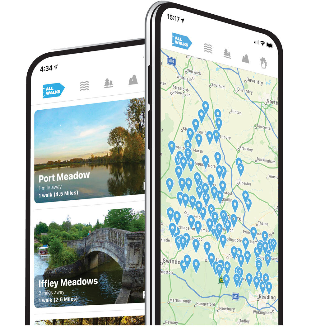
Our walking app provides easy to follow routes, showing your position on the map as you walk. It uses your phone GPS to guide you and gives you the confidence to explore and enjoy new walks in Oxfordshire. So, if you are looking for your next walking adventure, download the app, choose a walk and just follow the pointer.
It’s like sat-nav… but for footpaths.
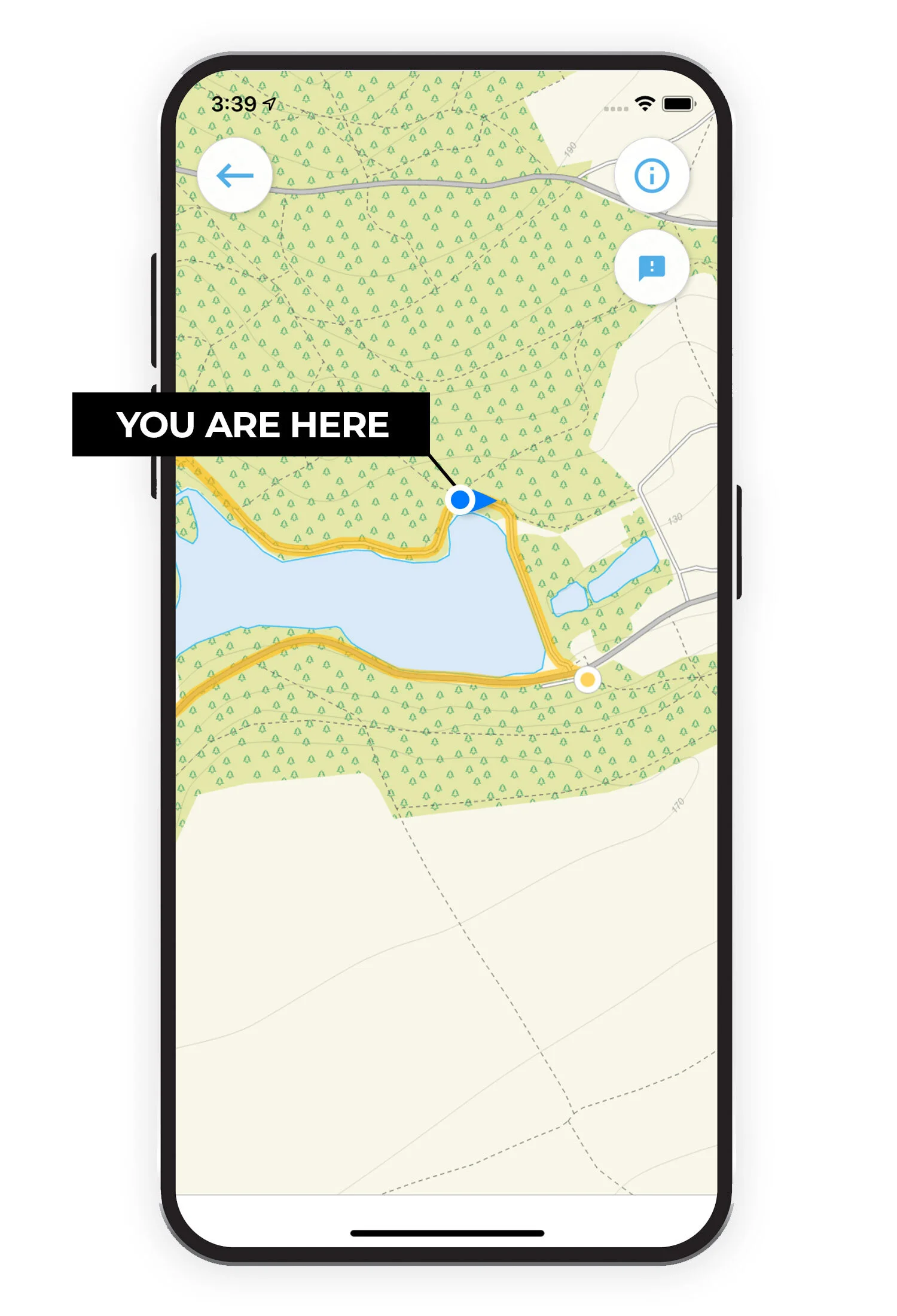
See your position on the route map as you walk.
Our mobile walking guide app includes over 250 walks in and around Oxfordshire. Download Oxfordshire Walks now on the iTunes or Google Play app store.

Join our community.
facebook.com/oxfordshire.walks
Like us on Facebook and join the 1,000’s of people who recommend, discover, feedback and enjoy new walks in Oxfordshire.
We love discovering new walks in Oxfordshire and our growing community help us find the best walks so that we can research and share them in the app. Our users can rate each walk based on a number of factors such as how dog or buggy friendly it is, pub on route etc, so that you can find your perfect walks.
If you want to join our community, go to facebook.com/oxfordshire.walks and get involved!
Check out a few of our Oxfordshire walks…


Download the Oxfordshire Walks app now!
Here is a list of the walks in Oxfordshire we have on the app…
Abingdon
1.75 miles
This is a lovely casual and varied walk around Abingdon. It enjoys some pretty walking through Rye Farm Meadow alongside the River Thames, before crossing the Abingdon Lock into the Abbey Gardens and then into the historic market town centre for a wander around the plentiful shops, pubs and restaurants on offer.
Abingdon
1.75 miles
This alternative walk is a short, nice and simple family-friendly walk that still takes you on the lovely walk along a stretch of the River Thames through Rye Farm meadow, but instead of visiting the town, it loops back to the car park through open countryside instead.
Abingdon
9.75 miles
If you really want to enjoy the River, this long route takes you on an epic journey along the winding River Thames, across the lovely rural Oxfordshire countryside and through the village of Clifton Hampden.
Adlestrop
1.5 miles
This is a lovely short loop around Adlestrop park, visiting the St Mary Magdalene church on the way.
Adlestrop
5 miles
This longer walk is a delightful stroll around the countryside surrounding Adlestrop. There is a section of walking through Adlestrop park and a beautiful stretch along the Diamond Way, visiting the villages of Daylesford and Lower Oddington. There is some roadside walking on this route.
Adlestrop
8 miles
The longest adventure from Adflestrop is a beautiful long walk through fields, woodland and cotswold villages. There is some road walking in places but it's mainly countryside and there are some nice places to stop for refreshments on route.
Ardington
2.75 miles
This is a pretty short stroll in the countryside that you'll discover between the pretty villages of Ardington and West Hendred. There's a nice pub next to the church in Ardington.
Ardington
7.5 miles
The long route is a lovely circular walk starting from the pretty village of Ardington. The walk covers wide expanses of open countryside and farmland, there are also hills and a little road walking on this route. There is a nice pub in Ardington.
Ashbury
2.25 miles to 8.75 miles
Aston Rowant
2.25 miles
This is a lovely short family-friendly walk around the beautiful Aston Rowant Nature Reserve which is on the north western scarp of the Chiltern Hills. It provides wonderful views over the Oxford plain and on this route you have a mix of lovely countryside, wildlife, woods and hills.
Aston Rowant
5 miles
This is a longer walk around the Aston Rowant Nature Reserve which enjoys the same lovely countryside, wildlife, woods and hills as the short route, but also extends out along the Icknield way to take in more countryside and woodland.
Badbury Hill
3 miles
This walk starts at the top of Badbury Hill, with lovely views over the Oxfordshire countryside. The route takes you down through the woods, across farmland and loops back up again to the start. As you can guess from the name, there are some hills on this walk.
Badbury Hill
3.75 miles
This slightly longer route option is a lovely circular walk from Badbury Hill. It visits some open countryside, some nice woodland, the village of Great Coxwell and of course Badbury Hill itself.
Bampton
7.25 miles
This walk starts at the pretty ancient market town of Bampton which sits not far from the beautiful River Thames. The town is famous for being used for filming scenes in the popular TV drama ‘Downton Abbey’. From the town the walk travels south to the hamlet of Weald and through some lovely Oxfordshire countryside following easy, level footpaths to the River Thames and Rushy Lock and weir. After crossing the river you will have a delightful riverside stroll to the beautiful Radcot Lock. Admire the many boats and canal barges whilst you walk. Walk back along the river to then cross back over the river at Old Man's Bridge. The footbridge will take you to the northern side of the Thames where you will follow easy country lanes back into Bampton.
Banbury
1 mile
This is a simple and very family-friendly walk around the Spiceball park in the historic Oxfordshire town of Banbury. There is a small section of woodland walking, some walking alongside the River Cherwell and a nice play area for the kids.
Banbury
2.25 miles
This is an extension on the first walk that enjoys the Spiceball Park but then takes you on a stretch of walking along the Oxford canal and into the Historic Market town of Banbury for a stroll around the shops and a visit to the pretty church. There are plenty of pubs and restaurants on the route if you want refreshments on the route.
Banbury
2.75 miles
This walk is an alternative extension on the first route which instead takes you out of the back of Spiceball park, and then on an additional stroll alongside the Grimsbury Reservoir with it's nature reserve at the end before taking you on a stretch of walking alongside the Oxford Canal to get back to the park.
Beacon's Bottom
4 miles
This is a lovely casual walk in the countryside that you'll find between the villages of Beacon's Bottom and Piddington, just over the county border into Buckinghamshire. You can expect some moderate hills, lots of open countryside, some pretty woodland and a pub for refreshments half way around the route.
Bledington
2.5 miles
This short walk starts from the pretty village of Bledington, situated in the Evenlode Valley. This scenic village has a lovely green and still retains its 15th century church and Victorian maypole. The walk enjoys the village itself and then ventures out into the pretty countryside for a nice short family-friendly loop.
Bledington
4.5 miles
This longer route starts from Bledington and then travels through fields and meadows, in parts touching the Evenlode River and also joining the Diamond Way for a short distance. On route you will travel through the delightfully peaceful village of Kingham which was once chosen 'England's Favourite Village’ by Country Life.
Bledlow Ridge
3.75 miles
This lovely walk will offer you a variety of glorious Oxfordshire scenery including the Yoesden Nature Reserve (often known as Yoesden Bank), with it's beautiful woodland and grassland and a visit to the church in the village of Radnage.
Bledlow Ridge
6.5 miles
This extended walk will offer you a variety of glorious Oxfordshire scenery including Lodge Hill for some great views and the Yoesden Nature Reserve. There is some road walking on this route.
Blewbury
4.75 miles
If you want some fresh air and open countryside with nice views, then this is the walk for you. The walk takes you on a steady ascent up Churn Hill to the top of Blewbury Down before looping back, downhill all the way, to the car park.
Blewbury
6.75 miles
This route is an extended version of the first route and it simply enjoys more walking up in and around the Blewbury Downs. Fresh air and views a plenty on this route!
Blewbury
8.75 miles
This route is a truly epic adventure in and around the Blewbury downs. It takes you on a long ascent up into the downs and then through open countryside until you reach the village of East Ilsey where there are a couple of pubs for a half time pit-stop. It then loops back on another epic walk through the downs to get back to the car park. Expect lots of energy usage, fresh air and lovely views.
Brill
1 mile
Just over the border into Buckinghamshire you will find this short and sweet stroll around the pretty Brill Common with it's beautiful windmill, open common land and some woodland to walk through. There is a small amount of road walking on the route.
Brill
2.75 miles
This is an extended walk around the village of Brill. The walk of course visits the beautiful windmill on the common in Brill, but then takes you back and on a walking loop through the village and then on a climb up Rid's hill for a pleasant walk through Chinkwell Woods before descending back to the village. The climb is relatively strenuous, so go prepared with plenty of energy.
Burford
6 miles
A beautiful and interesting walk across farmland, along pretty country lanes and parts of the River Windrush. This walk also has the bonus of passing through Burford High Street with plenty of pubs, tea and antique shops. There are some paths during the walk which run alongside roads.
Burton Dasset Hills
1.75 miles
This is over the county border slightly into Warwickshire, but it's a nice walk around the impressive Burton Dassett Hills country park. You'll climb some hills for some lovely views and visit the pub in the village of Northend for some refreshments if you so desire.
Burton Dasset Hills
6 miles
This is a longer route from the Burton Dassett Hills country park. You can explore the park itself at your leisure of course, but this route then takes you out on a journey around the surrounding countryside with visits to the villages of Fenny Compton, Northend, Burton Dassett and Avon Dasset all on the route.
Buscot
4.25 miles
This is a lovely walk from Buscot that takes in a wonderful stretch of the River Thames, takes you on public footpaths through lots of open farmland and visits the pretty villages of Buscot and Kelmscott with it's fantastic pub.
Chalgrove
5 miles
This is a nice and simple countryside walk around the village of Chalgrove. You can expect lots of fresh air and open countryside as you walk along the Shakespeare's way in a loop to the west of the village. The walk visits the village of Newington on the way around and there are two pubs to choose from in Chalgrove itself.
Charlbury
2.5 miles
Plenty of lovely walks to choose from around Charlbury, and this is the shortest family-friendly option. Even though it's shorter, it packs a lot of variety with a stroll through Mill Field alongside the River Evenlode, some lovely open countryside, a walk through the Wigwell Nature Reserve and of course a walk around Charlbury itself.
Charlbury
4.75 miles
This route is a walk across open countryside and farmland with views of the River Evenlode. This walk also takes you through the village of Charlbury where you can stop for refreshments. There is some road walking.
Charlbury
4.75 miles
This alternative route is a gentle walk through the fields and farmland around Charlbury and it also visits the village of Spelsbury. There is some road walking.
Charlbury
6 miles
This longer route heads into the countryside south of Charlbury. If you head clockwise, it enjoys some nice views as you walk down the hill, it visits the village of Finstock and then heads back to Charlbury via the pretty Cornbury Deer Park.
Charlbury
7.5 miles
This is our epic adventure route from Charlbury. It enjoys lots of lovely countryside, a visit to the village of Finstock, a stroll through the Cornbury Deer Park and a lovely stretch of walking through the majestic Wychwood Forest.
Chastleton House
1 mile
This is a lovely short family-friendly loop around the Chastleton House National Trust property. The loop visits the house itself that you can enter for a fee (see National Trust website for details) and then loops round on a short stroll through pleasant countryside and woodland.
Chastleton House
3.75 miles
This middle route is a nice casual walk around the countryside that you'll find between the villages of Chastleton and Adlestrop. You'll visit Chastleton house of course (fee applicable if you want to go in) as well as visiting both villages and enjoying lots of lovely countryside. There is some moderate hill climbing on the route.
Chastleton House
6.25 miles
This longer route is a lovely walk through some undulating countryside around Chastleton. Aside from the short stroll into Chastleton itself (where you can visit the National Trust property for a fee), it then ventures out and climbs Chastleton Hill which affords some nice views before visiting the village of Cornwell and then the Chastleton Barrow on the way back around. There is a reasonable amount of road walking on this route.
Checkendon
3.5 miles
This is a nice casual walk around the countryside to the south of Checkendon. The walk visits the village itself and walks through some open countryside, but the vast majority of the walk is through pretty woodland. There is some road walking on the route as well as a nice pub for refreshments if required.
Checkendon
5.5 miles
This extended walk takes you through various woods including College Wood and Lackmore Wood, across open countryside and through the villages of Woodcote and Checkendon. If you want refreshments, there is a small detour to a nice pub half way around the route. Note: There is some road walking on this route and you have to cross the fast A4074 road.
Chilton
3.5 miles
This is a pleasant and simple stroll out to the east of the village of Chilton. It first follows a path along an old railway track towards Upton, and then it loops back along the Lynchway track through open countryside. There is a nice pub half way around the route when it reaches Upton.
Chimney Meadows
6 miles
The walk passes through the Chimney Meadows Nature Reserve, past the hamlet of Duxford with its pretty thatched cottages and then along a beautiful stretch of the River Thames.
Chipping Norton
3 miles
This is a lovely short and family-friendly circular walk from Chipping Norton, which is a typically quintessential Cotswold market town. It visits some pretty countryside and the nice village of Over Norton before heading back to Chipping Norton where you can find plenty of shopping and refreshments.
Chipping Norton
5 miles
This route is an extended version of the first route. It still enjoys the pretty countryside and the village of Over Norton, but it also takes you along Shakespeare's Way through farmers fields to the village of Salford on the route. This offers more open countryside and exercise on your walk before getting back to Chipping Norton for your well earned reward at one of the town's eateries.
Chipping Norton
8 miles
This longest route also starts from the lovely old market town of Chipping Norton. From here you will walk to the village of Salford and across open countryside and farm fields to visit the famous and mystical Rollright Stones, visiting the small village of Little Rollright on the way. The walk then continues on to the pretty village of Over Norton and then back to Chipping Norton where, after your good leg stretch, you can be tempted by the range of shops, cafe’s and hostelries.
Christmas Common
2.75 miles
This is a short but rewarding short pub walk around Christmas Common. It enjoys lots of beautiful woodland paths that are spectacular in bluebell season, a big climb that is rewarded with an epic view over the whole area (walk the route anticlockwise) and a wonderful pub in Christmas Common that makes this a perfect day out. There is a bit of quiet road walking on the route and one steep climb.
Christmas Common
3.75 miles
This slightly longer route is just as pretty as you enjoy a walk around Watlington Hill. There's a fair bit of climbing, so go prepared with some energy and expect to enjoy some lovely views and pretty woodland. There is a small section (about 250m) of walking alongside a pretty fast road, so please be careful.
Christmas Common
5 miles
This third route is a slightly longer walk that offers a scenic circular woodland adventure. This route takes you east around Christmas Common towards the village of Northend and it provides you with more lovely views over the Chilterns. There are some steep hills to climb on this walk as with most routes around Christmas Common and a section of road walking at the start as you walk into the village from the car park.
Christmas Common
8.5 miles
This longest route is a truly epic and strenuous walk around the beautiful area of Christmas Common. There are lots of hills to climb and descend as you go on an adventure to the village of Turville Heath and through Turville Park. There is a section of road walking into Christmas Common at the start and lots of energy required throughout the route, but the pub in the village is wonderful for topping up that energy after the walk.
Claydon Locks
3.75 miles
This is a lovely simple stroll in the Oxfordshire countryside around the village of Claydon. The bulk of the walk is about peaceful canal-side walking and you'll walk a long stretch alongside the Oxford canal passing a series of locks as you go. The rest of the walk loops back around to the carpark via quite country lanes and open field footpaths.
Compton
3.75 miles
This is a lovely short walk from the village of Compton, just over the county border into Berkshire. The walk takes you around the Berkshire Downs, so expect to use up some energy on this walk, as well as enjoying plenty of fresh air and lovely views on the way.
Compton
6.5 miles
This longer circular route starts from the village of Compton and takes you through open farmland and countryside, with more far reaching views. About half way, you can then climb Lowbury Hill and round barrow which has long been regarded as the site of a probable Romano-British temple.
Cothill
0.5 miles
This is a short but sweet family-friendly stroll around the Dry Sandford Pit nature reserve. Expect a fascinating mosaic of fossil-rich cliffs, fenland with ponds and streams, grassland, scrub and woodland set in an old quarry.
Cothill
3 miles
This slightly longer route is a lovely walk that takes you further around the Cothill Fen Nature Reserve as well as along some country lanes and through farmland. At the end of the walk, there is a nice pub for refreshments and you can combine this route with the first Dry Sandford Pit route in a figure of 8 if you wish to extend your walk in this area.
Cottisford
2.25 miles
This is a wondertful short family-friendly circular walk that enjoys a stretch of walking through Shelswell woods and then a walk through the pretty Shelswell Park.
Cottisford
4.25 miles
This alternative route from this starting spot heads west through the village of Cottisford and then takes you on a loop around the pretty park land of Tusmore Park. It will also visit the delightful Obelisk when you get to the park.
Cottisford
8 miles
This is an epic adventure around the delightful countryside that you'll find around Cottisford. The walk visits the Shelswell Woods, takes you through Shelswell park, visits the villages of Hethe and Hardwick and finally enjoys the wonderful parklands and obelisk of Tusmore Park.
Cowleaze Wood
0.75 miles
This is a short family-friendly stroll around the pretty Cowleaze Wood that can be great for bluebells in the spring. You'll visit a squadron memorial half way around the walk.
Cowleaze Wood
4.25 miles
This route is an alternative longer walk from the Cowleaze Wood car park in the Chiltern Hills. It first follows a steep descent down either Shireburn Hill or Bald Hill (depending which direction you walk) and you'll then join up with the Swan's Way at the bottom for a walk along the Ridgeway before starting the climb back up to the car park. You'll need some good energy for this walk.
Cropredy
2.75 miles
This is a lovely casual walk from the pretty village of Cropredy in Oxfordshire. The walk visits the village itself with it's delightful pub and then takes you on a loop that walks alongside the Oxford Canal for a decent stretch and also enjoys some nice open countryside.
Deddington
1 mile
This is a nice short family-friendly stroll around the small town of Deddington. You'll visit the pretty Saints Peter and Paul church before venturing out to roam around the site where earthworks mark the existence of the 11th century Deddington Castle. There are pubs and eating options in the town centre if you want to make this a pub walk.
Deddington
6.25 miles
This more substantial walk starts in the small town of Deddington where you will find numerous shops, pubs and restaurants. The route takes you through the lovely Oxfordshire countryside, including country lanes and farmland. Half way around, you will walk through the hamlet of Clifton. If you make this a pub walk, you can visit a pub in either Deddington at the end of the route, or in Clifton half way around.
East Hendred Down
3.5 miles
This is a nice and simple walk around the East Hendred Down. You'll visit the Scutchamer Knob Iron and Barrow before walking on a nice loop of open countryside around the down itself. Plenty of fresh air and some lovely views on offer here.
East Hendred Down
5.75 miles
On this longer route, you'll first visit the Scutchamer Knob iron age barrow before descending down the hill to the north on a ramble around some open countryside around the small villages of East and West Ginge. You'll walk along a section of the Icknield way on this route, and also track the Ginge Brook for a while. There is a moderate climb on the route to consider.
Ewelme
3.75 miles
This is a nice pleasant countryside stroll in the gentle downs surrounding the village of Ewelme. Expect lots of fresh air and some nice views on this walk.
Ewelme
6.5 miles
This longer route extends the first route by taking you up onto the Swyncombe and Ewelme Downs. There is a lot more hill climbing on this longer route, so go prepared with lots of energy, but you will be rewarded with some wonderful views as you go.
Ewelme
11.75 miles
The final route is an epic and strenuous adventure from Ewelme that provides a variety of scenery to enjoy, ranging from woodland walks, country lanes, villages, lovely views, hill climbing and a stretch of the Chiltern way. About half way around, there is a steep descent to visit Russell Water Common and a nice pub for some refreshments before climbing back up to rejoin the route.
Eynsham
0.25 miles
This is just a short little stroll, great for the little ones or a dog walk. You'll enjoy some pretty woodland and a walk around the pond with all the nature that that brings.
Eynsham
4.25 miles
This longer circular walk wanders through the countryside to the South of Eynsham. You'll enjoy lots of open countryside and riverside walking in equal measures on this route making it a nice varied adventure. There is a not so glamorous section alongside a busy road on the route, but it's not too long and there's an added bonus of a pub on this section if you want a pitstop.
Faringdon
1.75 miles
This is a short and pretty family-friendly stroll around the market town of Faringdon. You'll walk through the town itself and then venture out to visit the Faringdon Folly for some nice views. There are plenty of options for refreshments in the town itself.
Faringdon
7.75 miles
This is a much longer walk if you want to stretch your legs and explore the countryside to the east of Faringdon. You'll cross open countryside, walk through some pretty woodland and visit the Folly Tower on route to take in the scenic views.
Farmoor Reservoir
4 miles
Walking amongst nature is good for us and this relaxing walk has nature all around. Farmoor Reservoir, where you can watch wildlife, meander along the beautiful River Thames and explore a delightful woodland. Whilst you’re walking, stop every now and then to listen to the birdsong - food for the soul.
Filkins
5.5 miles
This is a lovely walk in the delightful Cotswold countryside. The walk starts in the Cotswold stone village of Filkins and takes you on a casual adventure around some pretty countryside visiting the villages of Broadwell and Langford on the way. There is also a fantastic pub waiting for you when you return to the village of Filkins.
Fingest
4 miles
Another short drive over the border into Buckinghamshire here, but the journey is completely worth it to enjoy this stunning walk in the delightful Hambleden valley. Park on the roadside in the pretty village of Fingest, or in the wonderful Chequers pub if you're booked in for lunch after your walk. Then, simply enjoy this world class walk around beautiful undulating countryside dotted with dramatic woodland and incredibly pretty villages. If you have the energy, there's an optional trek up the hill to the windmill to get some breathtaking views of the valley.
Fingest
5.75 miles
This extended version of the Fingest walk is a truly beautiful adventure, but be warned the hills are pretty huge and plentiful. This means that you will need a lot of energy before you embark on this route, and make sure you take all the refreshments you need. Of course you will be rewarded for this hard work with more stunning views of this fantastic part of the English countryside, and you can then truly enjoy a reward at the gorgeous Chequers pub when you have finished the walk.
Finstock
2 miles
A short family-friendly walk around the village and surrounding area of Finstock. This route takes you across open fields and farmland and along the peaceful roads and lanes that run through the village. There is a lovely pub for refreshments in the village.
Finstock
4 miles
This longer route option heads further southeast from the village and it is a lovely walk with open countryside, woodlands walking, and a visit to the hamlet of Wilcote. The pretty village of Finstock then provides a great pub for post-walk refreshments.
Fringford
3 miles
This is a lovely walk around the pretty countryside that you'll find around the village of Fringford. Lots of fresh air, open countryside and a delightful pub to enjoy make this a great day out for all the family.
Glympton
3.5 miles
A short family-friendly circular route encompassing a walk through the two thousand acres estates of Glympton and Kiddington. The route takes you across parkland, woodland trails and open rolling countryside. There is a village shop at Glympton for refreshments. There is a bit of road walking in the loop around Kiddington Estate, so you could go in and out instead to avoid the road on that section if you wish.
Glympton
6.75 miles
This is a loverly long walk around the pretty countryside surrounding the village of Glymption. As with the short route, you'll visit the public footpaths running through the Glympton Park and Kiddington Park estates, but then the walk extends on a longer adventure south of the parks, visiting woodlands and lovely open countryside on the way. There is some busy road crossings and some sections of roadside walking on this longer route.
Glympton
10.5 miles
This truly epic walk is an extension of the second route that also takes in the impressive Ditchley Park and some extra pretty countryside walking. This is a long walk, and no refreshments or pubs on the way around, so go prepared with plenty of food and water.
Goring
1.5 miles
This is a short family friendly walk around the historic village of Goring. You'll walk around the village itself, visiting the pretty church and rectory gardens on the way, and then you'll enjoy a stretch of walking alongside the majestic River Thames.
Goring
3.75 miles
This is a longer route option from Goring that explores the historic village and it's church, but also enjoys a much longer stretch of walking alongside the River Thames. There is quite a lot of walking along a quiet lane on this route.
Goring
5 miles
This is an extension of the second route, which enjoys the same longer stretch of walking alongside the River Thames and the village itself. However, instead of the long walk along the quiet lane, it ventures out into the open countryside, hills and Great Chalk woodland that you'll find to the east of Goring. We think this is a nicer and more adventurous route than route 2, but it's longer and there's more hill climbing involved if you want more of a workout.
Goring
5.5 miles
This route is the one for you if you want more of a workout and just want to explore the undulating countryside to the east of Goring without visiting the river. It takes you on an adventure through open countryside, it climbs and descends the hills of the area and it visits the Wroxhill, Park and Great Chalk woodlands. The pub is next to the car park at the start.
Goring
7.5 miles
This final and longest route basically has the best of all the other routes. It explores the historic village of Goring with it's pretty church, it enjoys the long stretch of walking alongside the lovely River Thames, and it takes you on a long and strenuous workout walk through the countryside, hills and woodland that you'll find to the east of Goring.
Great Rissington
3 miles
This circular walk starts and finishes at the charming village of Great Rissington and takes you along easy paths through fields and light woodland until you reach the meandering River Windrush. Here you will find some nice little spots to stop and enjoy before heading further along the river in the shade of the trees. The easy return route then takes you back to the village along a ridge with lovely views overlooking the Windrush valley.
Great Rissington
6.25 miles
This route is an extended version of the first route that heads into the countryside south of Great Rissington. This longer route basically enjoys a lot more open countryside, and touches on the villages of Windrush and Sherbourne as you walk.
Greys Green
2.75 miles
This first walk is a short stroll around and through the golf course to the south of Greys Green. Please stick to the public footpaths on the route and be respectful of any golfers playing on the course.
Greys Green
4.75 miles
The second route is a longer adventure in the countryside to the south and west of Greys Green. It skirts the golf course as with the shortest route, but also ventures further west past the village of Rotherfield Peppard and into the majestic Kingwood Common woodlands.
Greys Green
8 miles
This is our longest route from Greys Green. You can expect lots of leafy woodland tracks, open farmland, some short steep hills, and the National Trust's Greys Court on this route. The extra distance will help you work up an appetite, so you'll be glad to know that there's a lovely pub in the village of Rotherfield Greys if you need to top up your energy.
Henley-on-Thames
1.25 miles
This is a short family-friendly stroll around the Mill Meadows in the wonderful town of Henley-on-Thames. This route is a simple walk that takes you along the River Thames via the pretty Marsh Meadows and then takes you on a path through some nice woodland. Finally, it visits the Mill Meadows adventure playground which is great for the kids.
Henley-on-Thames
3.5 miles
This is another relatively short walk around the wonderful town of Henley-on-Thames. This route heads north from Mill Meadows, crosses the bridge and then takes you on a lovely loop of walking made up of woodland, open countryside, quiet lanes and of course a stretch of walking alongside the River Thames at it's best. You can combine this route with the first route to create a longer route if you wish, and there are plenty of lovely eateries in the town itself.
Henley-on-Thames
5.75 miles
This route is an extension of the second route that enjoys a longer stretch of walking alongside the wonderful River Thames. It takes you further along the river past the village of Remenham and it follows the river all the way around until it passes the impressive Hambleden Lock and then reaches the village of Aston. The path between Aston and Henley is then open countryside and a section through Remenham woods.
Henley-on-Thames
10.5 miles
This is a truly fantastic and epic adventure that really explores this beautiful part of the county. The walk takes you through the pretty town of Henley-on-Thames before following the River Thames all the way up to Mill End and crossing the impressive Hambleden Lock. It then heads north into the beautiful village of Hambleden (where you'll find a great pub for refreshments!) before heading west into and through the Great Wood. Finally, the walk returns to Henley via quiet country lanes and through Henley Park's lovely open countryside. There are a lot of steep hills on this very long walk, so please go prepared with enough food, water and energy.
Heyford
3.5 miles
This is a lovely circular walk between the villages of Upper and Lower Heyford. The star of the show is the long stretch of walking alongside both sides of the River Cherwell and Oxford Canal, but the walk also visits both of the pretty villages which each have their own church and pub to visit.
Heyford
6 miles
This longer route is an extended version of the walk and it visits the Heyford villages as well as the village of Steeple Aston on the edge of the Cherwell Valley. You can expect scenic views across fields, farmland and woodland and a stretch of walking alongside the River Cherwell and Oxford Canal.
Iffley Meadows
2.5 miles
This is a lovely family-friendly wander around the pretty Iffley Meadows and Longbridge Nature Park. You'll enjoy lots of nature, the open meadows, some woodland walking and a long stretch of roaming alongside the River Thames.
Lambourn Downs
2.5 miles
This is a short but moderately strenuous walk around the wonderful Devil's Punchbowl and Crowhole Bottom area of the Lambourn Downs. Expect lots of far reaching views and some steep climbing on this route.
Lambourn Downs
7 miles
If you really want to stretch your legs and explore the open exposure of the Lambourn Downs, this long route takes you on an adventure along the Ridgeway and deep into the downs. You can also link this walk to the first route to enjoy the Devil's Punchbowl if you wish.
Lambourn Downs
8.75 miles
If you have the energy and time available for a truly epic walk, then the third route is a simple extension to the second route. This route offers more mileage for energetic legs, more lovely views and more open sweeping countryside.
Long Compton
4 miles
This is a casual countryside walk that you'll find just over the border into Warwickshire. It explores some nice open countryside, visits the village of Long Compton and walks a stretch through the Long Compton woods.
Lower Brailes
2.75 miles
This is a lovely short stroll around the pretty Cotswold village of Lower Brailes, just over the border into Warwickshire. The route takes you through some nice open countryside for fresh air, it takes you to the top of Castle Hill for some nice views and it visits the village itself with it's lovely pub and nice church.
Lower Brailes
4.75 miles
This is a lovely circular walk around the undulating countryside that you'll find around the Brailes villages, just over the county border into Warwickshire. There can be mud on the route, so please wear appropriate footwear if it's wet, and be prepared for some hill climbing. There is a lovely pub in the village of Lower Brailes itself.
Maidensgrove
4.5 miles
This is a lovely casual walk around the countryside that surrounds the Warburg Nature Reserve (there is a separate walk on the app if you want to explore the Nature Reserve itself). You can expect lots of fresh air, open countryside and some pretty woodland walking on this route. You'll also have a good workout as the whole area is quite hilly with moderately steep ascents and descents.
Maidensgrove
6.5 miles
This is an extended version of the first route if you want to stretch your legs a bit more. This route enjoys the same countryside, hills and woodland of the first route, but it also extends to visit the village of Nettlebed where you'll find a nice pub, and takes you on a walk through the Nettlebed Woodland Common on Windmill Hill.
Minster Lovell
3.5 miles
This is a beautiful short and casual walk between the fabulous Cotswold villages of Minster Lovell and Crawley. Expect water meadows, wonderful rolling countryside and some romantic walking alongside the River Windrush. There are great pubs in both villages to enjoy making this a perfect relaxed pub walk.
Moreton-in-Marsh
5.5 miles and 7 miles
These walks are a short distance over the county border into the Gloucestershire Cotswolds.
Moulsford
10 miles
This is a very long walk that starts in the village of Moulsford. It is an epic adventure for those that really want to stretch their legs, and it includes an array of different landscapes including woods, meadows, hills, country lanes and a nice stroll along the River Thames. There are pubs on the route and there is also some road walking in places.
North Leigh
1 mile
This is a nice and short family-friendly woodland walk around the pretty North Leigh Common.
North Leigh
4.75 miles
This is a longer and more varied adventure from the North Leigh common car park. The walk takes in the woodland of the North Leigh Common of course, but then heads north and visits the village of East End with a trip to a fantastic roman villa before then taking you through open countryside to the village of North Leigh itself.
North Newington
3 miles
This walk starts in North Newington village and it takes you on a journey to Broughton Castle, which is a medieval fortified manor house. The walk continues through parkland, across open countryside and farmland before reaching the village of Broughton and then working it's way back to the start point. There is some road walking on this route and there are nice pubs in both villages.
Otmoor Nature Reserve
5.75 miles
This is a walk for all you lovers of nature and wildlife. The Otmoor Nature Reserve spans 1,000 acres of diverse wildlife and marshland that had previously been farmland. The reserve is managed by the RSPB and is the wintering ground for thousands of wildfowl and waders.
Otmoor Nature Reserve
7.25 miles
This is an extension on the first route. The main hero of the walk is still the walk around the rich nature reserve, but this option heads further out to join the Oxfordshire Way, visiting the pretty village of Beckley with it's fantastic pub for refreshments and venturing on a public footpath through the grounds of Beckley Park.
Oxford
3.75 miles
This is a circular city walk that explores the delightful county city of Oxford. Walking clockwise from the Oxpens car park, you will visit the Grandpoint Nature Park, walk along a stretch of the River Thames, stroll through Christ Church meadow and then embark on a long walk through the historic city centre itself, where you'll find plenty of pitstops for refreshments and shopping if you so desire.
Piddington
4.5 miles
This is a lovely walk around the countryside that you'll find around the village of Piddington. The walk is varied with a small section of woodland, lots of open countryside and an ascent to Muswell hill for some lovely views. There is some moderate climbing and some road walking on this route.
Port Meadow
4.5 miles
This lovely stroll north of Oxford is a family-friendly circular walk along the River Thames and around Port Meadow. The route takes a little detour out of the meadow half way around to visit the lovely pub in Wolvercote if you need refreshments as part of your day out.
Rushy Common
2.25 miles
This is a lovely short family-friendly walk around the Rushy Common nature reserve. Starting at Rushy Common Nature Reserve and neighbouring Tar Lake, the paths around the lakes are a delight and there is plenty of wildlife to see.
Rushy Common
5 miles
This route is a longer extension of the Rushy common walk if you want to stretch your legs a little bit more and enjoy more walking alongside the River Windrush. This extended walk enjoys the lakes and nature reserve, but then continues along the Windrush Way following the path of the lovely meandering River Windrush. You will then continue along the Northern Cross Valley Way and finally the Down Valley Way which will take you back to the car park at Rushy Common.
Saunderton
6.5 miles
This is a nice varied circular walk from the station car park in Saunderton, which is just over the county border into Buckinghamshire. There is a fair amount of moderate hill climbing on this route as it takes you up to the village of Bledlow Ridge, where you'll find a pub if you need refreshments. The walk then loops around this hilly area visiting the village of Rout's Green and climbing Lodge Hill as you go.
Saunderton
11.5 miles
This longer route is an epic adventure that starts in the village of Saunderton in the Chiltern Hills and travels west, climbing up a moderate hill towards Bedlow Ridge. From there you will pass Crowell Wood, walk through Sunley Wood and climb Lodge Hill for some great views. There is some road walking on this route and please go prepared with lots of energy. There are some pubs around the route for refreshments.
Shillingford Bridge
1 mile
This is a short and simple family-friendly riverside stroll where you can enjoy a walk alongside the majestic River Thames before looping back to the hotel where you can enjoy some post-stroll refreshments. There is a small fee for parking at the hotel unless you are a going to be a customer of the hotel - if so, pop in and register your car before you walk.
Shillingford Bridge
4.75 miles
This is the middle length route from Shillingford Bridge Hotel. It enjoys the riverside walking and takes you deep into Little Wittenham woods as well as giving you plenty of fresh air through open farmland. It avoids the climb up to the Wittenham Clumps though which is part of the longest route below if you have the energy. Parking at the hotel must be paid in advance.
Shillingford Bridge
6.25 miles
This is the longest route from Shillingford bridge and it's a lovely walk full that has a bit of everything. There is the short stretch of walking alongside the river thames, plenty of open farmland, a walk through Little Wittenham woods and a climb around the Witten ham clumps for some great views. The parking at the hotel is paid, so please pop in to organise this before you walk.
Shotover Country Park
3.5 miles
Sonning Common
2.75 miles
This is a lovely short pub walk from the village of Sonning Common. Park on the roadside somewhere around the Hare and Hounds pub and head clockwise around this route. It takes you through some lovely woodland areas through Shiplake Bottom and Peppard Common before visiting a delightful church and then enjoying some great views as you walk back down Shiplake Hill to Sonning Common and your reward in the Hare and Hound's beer garden.
Sonning Common
3 miles
This alternative route from the Hare and Hounds pub in Sonning Common is more of a woodland adventure and heads east deep into and around the beautiful New Copse woodland before working your way back to the pub for your post walk reward.
Sonning Common
6.25 miles
The final route is a much longer and hugely enjoyable walk around the areas of woodland and countryside surrounding Sonning Common. It includes all of the best bits from the two shorter routes, but it also extends into the majestic Kingwood Common for even more dramatic woodland walking.
South Stoke
5 miles
A lovely casual walk along the River Thames. Starting in the Oxfordshire village of South Stoke, this route takes you along the River Thames until you reach North Stoke. You then loop back through open countryside to your starting point.
Spelsbury
2.5 miles
This nice short family-friendly walk starts in Spelsbury and takes you south west across Coldron Brook, then through and around the Dean Grove woodlands before looping back through countryside to Spelsbury.
Spelsbury
4.75 miles
This route is a longer extension of the first route that still visits the Dean Grove woodlands and the pretty countryside around Spelsbury, but it then takes you south along the Oxfordshire Way until it reaches the village of Charlbury. When you get there, you'll discover a stretch of walking alongside the River Evenlode, a pleasant stroll around the village itself and some lovely pubs to visit half way around this walk, before working your way back to Spelsbury through open countryside.
Steeple Aston
4.25 miles
This is a lovely varied walk in the countryside that you'll find around the pretty village of Steeple Aston. You'll stroll around the village itself, visiting the quaint local pub if you need refreshments, and then venture out into the countryside to enjoy plenty of fresh air and a delightful stretch of walking alongside the River Cherwell and Oxford Canal.
Stokenchurch
2.75 miles
Just across the county border into Buckinghamshire, you'll find this lovely set of walks from the village of Stokenchurch. This shorter route heads north from the village and takes you on an adventure through lovely open fields and the hilly woodlands of High and Crowell woods. There are plenty of pubs close to the start of the route for refreshments and there is some moderate hill climbing on this route.
Stokenchurch
5 miles
This walk is an extension of the first route and our choice pick from Stokenchurch. It still enjoys all the of the pretty woodland walking of the first route, but to make up some extra mileage, it rewards you with a lovely walk along the gorgeous Collier's Lane.
Stokenchurch
6 miles
This final alternative walking route is an epic adventure that takes you south of Stokenchurch. It heads under the M40, and then on to a lovely circular route through Penley Wood, visiting the hamlet of Idstone and Hartmoor Wood, before returning back to the start. There are plenty of hills on this long route, so please go prepared with refreshments and energy!
Stonesfield
5.5 miles
This pretty walk starts in the village of Stonesfield and takes you south for some lovely walking alongside the River Evenlode before visiting some woodland and the remains of a Roman Villa. There is a community pub in Stonesfield - The White Horse, but please call them to check that it's open.
Streatley
1.5 miles
This is a short but strenuous walk around Lardon Chase and Lough Down. There is plenty of climbing involved, so take lots of energy, but you will be rewarded with some lovely views at the top.
Streatley
2.25 miles
This second walk is an extended version of the first route that still enjoys the strenuous walk and rewarding views of the Lough Down, but also then heads for an extra adventure deep into the hilly woodland area to the south of Streatley. There are some steep ascents on this walk.
Tetsworth
2.5 miles
This is a simple and short countryside stroll around Tetsworth. It takes you through fields to the north of the village towards the golf course before looping back through more countryside.
The Rollright Stones
0.5 miles
This isn't a walk as such, but more a short family-friendly exploration of the mystical Rollright Stones, which are a complex of Neolithic and Bronze Age megalithic monuments.
Thrupp
1.5 miles
This is a short family-friendly pub walk from the Jolly Boatman pub in Thrupp. The route is simple and takes you on a stroll up and down the pretty River Cherwell before returning to the pub to sit in the riverside courtyard to enjoy a post-walk reward.
Thrupp
4.25 miles
This longer Pub Walk from the Jolly Boatman pub in Thrupp is a delightful and varied walk around the Oxfordshire countryside. Expect lazy canal-side roaming, haunted manor house ruins, open countryside, peaceful churches, farm animals and horses, lovely woodland paths and a little surprise oasis for the dogs.
Uffington White Horse
1 mile
This is a short family friendly stroll around the famous Uffington White Horse. If you follow the path up to the white horse itself, you will see the oldest chalk-cut hill figure in Britain. Despite being very modernist in it's design, experts suggest it is over 3,000 years old.
Uffington White Horse
5.5 miles
This longer alternative route still enjoys the white horse, but to add some distance and stretch those legs, it then travels southwards along an established track to Knighton Bushes and back to White Horse Hill via the gallops on Woolstone Down.
Upper Tysoe
5.25 miles
This is a delightful walk in the hills that you'll find to the south of Upper Tysoe (which is just over the county border into Warwickshire). You will ramble around and over both the Lady Elizabeth's and Windmill Hills, so you'll use up a fair amount of energy on this walk. Of course, you'll be rewarded with some great views and lots of fresh air for your efforts.
Wallingford
5 miles
If you like a nice walk along the river, you will enjoy this figure of eight walk. Take a stroll around the historic market town of Wallingford, follow the majestic River Thames, walk through meadows, lovely countryside and visit the medieval Wallingford Castle.
Warburg Nature Reserve
2.75 miles
This is a delightful family-friendly stroll around the pretty Warburg Nature Reserve which is rich in exciting woodland, plants and animals. Please note that the road to the car park is in poor condition and may not be suitable for all vehicles.
Warburg Nature Reserve
4.5 miles
This is an extended alternative route that also passes through the spectacular Warburg Nature Reserve. However, this route also offers distant views, more wonderful ancient woodland, a pretty hamlet and the icing on the cake - a lovely traditional country pub with a garden providing views to die for.
Wargrave
5 miles
This is just a short hop over the border into Berkshire, but worth it for this lovely walk from the historic village of Wargrave. You'll walk up the hill from the village before embarking on a lovely loop through open countryside and dramatic woodland on Bowsey Hill. There is a fair amount of climbing on this route.
Wargrave
8.75 miles
If you have lots of energy, then this route extends the Wargrave walk to create an epic adventure that visits the dramatic woodland of both Bowsey Hill and also Ashley hill further to the east. You'll definitely work up an appetite on this one and can enjoy a reward after your walk at the lovely Bull Hotel close to the car park.
West Ilsley
4.75 miles
Just a short drive over the county border into Berkshire, you'll find this lovely walk up on the Ridgeway in the Berkshire Downs. Expect lots of fresh air and lovely views on this walk and a lovely pub half way around in the village of West Ilsley.
Wittenham Clumps
0.75 miles
This is a short, but lovely, walk around the much-loved chalk hills of Wittenham Clumps. There is a bit of climbing involved of course, but it's worth it for the lovely views.
Wittenham Clumps
2 miles
This longer route still enjoys the climb to the summit of the Wittenham Clumps, but it also extends further to visit the Little Wittenham Woods as well as the Days Lock on the River Thames.
Woodstock
6 miles
This is an alternative walk from the pretty market town of Woodstock, if you don't want to venture deep into Blenheim Park (see the second route if you do). This route takes you north of the town towards the village of Wootton, passing through some of the wonderful Blenheim Park, across open countryside, past the River Glyme and along some country lanes.
Woodstock
6.5 miles
This is our recommended walk from the pretty old Oxfordshire market town of Woodstock and as well as exploring the town, it also takes you deep into the beautiful Blenheim Park. On this walk you will be surrounded by lovely fields, wonderful parkland, towering old oak trees and a beautiful lake - all against the backdrop of the magnificent Blenheim Palace itself.
Map image credit:
© OpenStreetMap contributors
Contains OS data © Crown copyright and database right 2021