
At a glance
Burford Walk
- Distance
- 6 miles
- Estimated time
- 3 hours
- Route type
- Circular
- GPS app guided
- Yes
- Parking
- Free car park at start 51.80843, -1.63341
- Characteristics
- Woodland, Water, Countryside, Town, Pub
Oxfordshire Walks
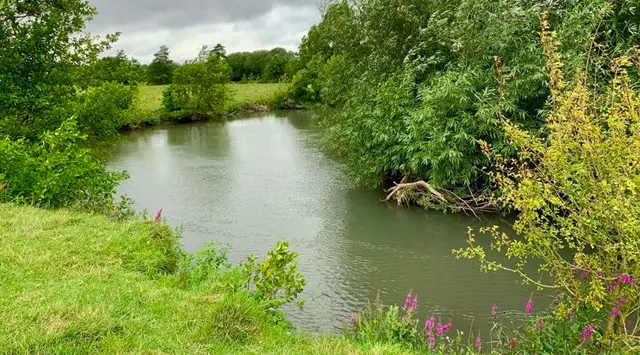
This lovely Burford walk starts in the pretty medieval town and meanders along paths beside the beautiful River Windrush, through fields and water meadows, and along a valley fringed by woodland either side. There is also a small isolated medieval church to visit.
Download the Oxfordshire Walks App to follow this route with real-time GPS navigation.


On a computer? Scan the QR code with your phone's camera to get the Oxfordshire Walks app.
At a glance
The walk
We are staying near Burford in the wonderful Windrush Valley for this weekend’s classic cotswold walk. Starting from Burford, one of the most picturesque towns in England, the walk explores the Oxfordshire countryside surrounding this fascinating town.
This Burford walk is on both the Oxfordshire Walks app and the Gloucestershire & Cotswolds Walks app. To get the app just search for 'Oxfordshire Walks' or ‘Gloucestershire Walks’ on your app store.
This 6 mile walk starts from the beautiful medieval town of Burford, often known as a gateway to the Cotswolds. The town is famous for its fabulous High Street with its pubs, restaurants, cafes and shops. At the bottom of the High Street is a fine three arched medieval bridge under which flows the lovely River Windrush, renowned for its beautifully clear water.
Heading out of Burford town the walk takes you on easy grassy paths alongside the River Windrush to St Oswald’s Church. Standing in splendid isolation, in the middle of a field above the Windrush there are obvious signs through the lumps and bumps in the ground of the village that was once there. The main village of Widford was destroyed by the Black Death in the 17th century.
Leaving the little church behind, the path continues up to the top of the valley and on to the village of Fulbrook. From there you will return to Burford, where if you have time there are many fascinating medieval buildings to explore including the impressive St.John the Baptist Church, pretty old Almshouses and old weaver’s cottages - all down by the river.
There are many pubs and cafes to visit in Burford and also ‘The Carpenters Arms’ in Fulbrook. Close by but not on the route of the walk, are the very picturesque pubs ‘The Swan Inn’ at Swinbrook and ‘The Maytime Inn’ at Asthall. However, they may be busy so please call to check opening times and their current arrangements.
This is a walk for everyone but please be aware there are some gates, a few stiles and cattle grids. Enjoy and please send us your stories and photos to oxfordshire@localwalks.co.uk.
Based on 25 user ratings
A very popular walk
Very dog friendly
Reasonable paths
Not suitable for pushchairs
Not wheelchair accessible
Very limited facilities
Quite good
Accurate
Real feedback from people who have completed this walk using the Oxfordshire Walks app.
First-hand experiences
Beautiful walk. A few inclines on the route but they are not difficult. A few stiles on route but they are well maintainted. A few cattle grids to pass but you can easily naviagte them on the side. Completed in two hours and we didnt walk at a fast pace and stopped to take plenty photographs.
Be prepared if you do this walk after heavy rain that parts will be flooded and fields very muddy. Enjoyable walk otherwise
beautiful walk, we enjoyed it a lot :)
Very enjoyable but preferred the Swinbrook walk covering similar area. Burford is a nice village to end at
Overgrown in places and a long walk so be prepared and take a drink and use sensible footwear
Very interesting walk and had fun with kids
We really enjoyed this walk. Route was easy to follow. Dog was able to be off his lead a lot.
The field just leaving Fulbrook had been ploughed so the path wasn’t clear but we still easily found our way. The part of the walk by the river was impassable due to flooding but fortunately there was a road alongside. Very beautiful walk with nice views and we even stopped off at Widford Chirch for some medieval history.
First time doing this walk with our golden retriver - absolutley loved it! Some of the fields had flooded in the middle (plenty of space to walk around it) which my golden LOVED! Took us 2.5hr then had a pint at one of the pubs on Burford high street. Lovely morning!
Great walk thoroughly enjoyed the route!
I done this walk with my dog i done a run/walk and i really enjoyed it. One of the best walks i have done, some road walk where you require your dog to be on the lead but ocerall it was off road. A few cows on the route but nothing to bother us. ...I would definitley repeat this walk.
Excellent walk !
Comments from walkers who have completed the Burford walk.
Navigate the walks
The easiest way to follow this route is with the Oxfordshire Walks app. Choose the walk and follow the pointer showing your live position on the route map, so you can see you're on the right path.
The app works without a phone signal, so you can keep following the route wherever the walk takes you.
On a computer? Scan the QR code with your phone's camera to get the Oxfordshire Walks app.

Explore the area
 4.25 miles
 6-7.25 miles
 3.5 miles
 3-6.25 miles
 2.5-8.25 miles
 5.5 miles
 2.5-7.25 miles
 2.5 miles
 3.75-6.75 miles
 2-9.75 miles
 2.5-7.5 miles
 1.25 miles
 2.25 miles
 2.5-4.75 miles
 5 miles
Explore the county
See where the walks start, explore the area and tap a pin to find a route for your next adventure.
Search Oxfordshire walks