
At a glance
Breedon-on-the-Hill Walk
- Distance
- 6.5 miles
- Estimated time
- 3.5 hours
- Route type
- Circular
- GPS app guided
- Yes
- Parking
- Cloud Trail Parking 52.78524, -1.39715
- Characteristics
- Hills, Countryside, History, Pub
- Ascent
- 125 m
Derbyshire Walks
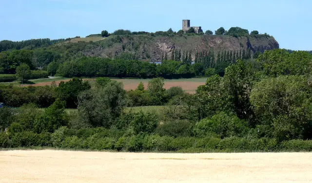
This walk explores the hilltop village of Breedon on the Hill and climbs the Carboniferous limestone ridge that gives it its name.
This walk includes a short, steep ascent to Priory Church of Saint Mary and Saint Hardulph for far-reaching views, passes the ancient Bulwarks hill fort, and continues towards Wilson along the Cloud Trail before looping back.
Download the Derbyshire Walks App to follow this route with real-time GPS navigation.


At a glance
The walk
This walk explores the village of Breedon-on-the-Hill and the Carboniferous limestone hill for which it is named. There is one short quite steep hill to climb but at the top you are rewarded with the Priory Church of Saint Mary and Saint Hardulph and gives distant views over the mostly flat countryside.
The Bulwarks Iron Age hill fort is visible on the descent of the hill. The route heads north to the village of Wilson to join the Cloud Trail.
There is some walking along quiet country lanes on this route, and a 350m stretch of walking on a busy road with grass verges.
Based on 2 user ratings
Mixed feedback from walkers
Dog heaven
Reasonable paths
Hard going with a buggy
Not wheelchair accessible
Very limited facilities
Not much on route
Accurate
Real feedback from people who have completed this walk using the Derbyshire Walks app.
First-hand experiences
Lots of long paths and roads to walk. Route was a little off where there was private land, so had to walk around the road. An ok walk, but wouldn’t do it again.
Comments from walkers who have completed the Breedon-on-the-Hill walk.
Time for a stop
Navigate the walks
The easiest way to follow this route is with the Derbyshire Walks app. Choose the walk and follow the pointer showing your live position on the route map, so you can see you're on the right path.
The app works without a phone signal, so you can keep following the route wherever the walk takes you.

Explore the area
 2.75 miles
 1.25-5.5 miles
 3-6.75 miles
 1.75 miles
 5.75 miles
 2.25-5 miles
 2.25-4 miles
 2.25 miles
 4.75-6.75 miles
 2.25-3.5 miles
 2.5-6.5 miles
 1.5-2.25 miles
 3.5-5.25 miles
 4.5 miles
 1.25-4 miles
Explore the county
See where the walks start, explore the area and tap a pin to find a route for your next adventure.
Search Derbyshire walks